|
|
Time is drawing near for the next race from Lake Havasu, AZ to Batavia,
OH. Race dates are June 19-22, 2012 but we will be in Lake Havasu by June 14th to do our pre-race inspections and briefings. But wait ... Start watching the SPOT tracker to see where we are going BEFORE the race. We are planning our itinerary now to take advantage of the long trip out to AZ - no point in wasting the fuel when there are sites to be seen. 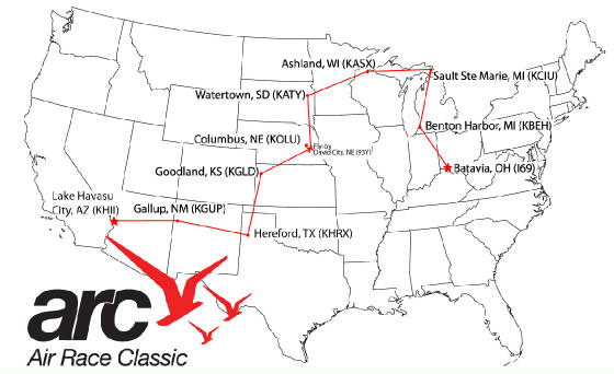
Memorial Day Weekend: Our scheduled handicap flight for Saturday did not fly. Although the weather forecast was good, the fog rolled in and Marvin ended up orbiting above Venice while Wild Mama and I sat on the ground in the fog with 1/4 mile visibility. The forecast for Sunday morning was much the same, although I woke up Sunday to a crystal clear 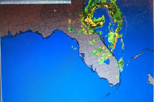 morning. Hopefully, the next planned flight on Monday will be a winner, although Beryl might have other ideas .... morning. Hopefully, the next planned flight on Monday will be a winner, although Beryl might have other ideas .... We were shooting for Friday, June 1st for the handicap run but a storm system moved in from the south on Thursday afternoon. Saturday looks good, however, and we are hoping to finally get this done. With departure only 3 days away, the time is growing short. The other order of business was our IFR certification which ran out today. We had hoped to get it tomorrow to "buy and extra month" but got stuck in a catch 22: if we waited 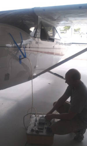 until tomorrow, we could not fly IFR because the certification was now out and the weather was forecast to be IFR. Shucks!!!!
Do it today. I hopped over to Tomlisons Avionicsfor the job. They have constructed the whole avionics panel and know her pretty well. Phil worked his magic and did all of
the required testing before we buttoned her back up and brought her back home. Now de-bug, clean the windshield and start
the post flight, pre-race ritual. until tomorrow, we could not fly IFR because the certification was now out and the weather was forecast to be IFR. Shucks!!!!
Do it today. I hopped over to Tomlisons Avionicsfor the job. They have constructed the whole avionics panel and know her pretty well. Phil worked his magic and did all of
the required testing before we buttoned her back up and brought her back home. Now de-bug, clean the windshield and start
the post flight, pre-race ritual. June 1st: Just as forecast, the weather was not good for a handicap run, although it was not as bad as it could have been. Here we sit again. The forecast for Saturday, again, is NOT looking promising with rain and high winds. After a brief email exchange with Marvin, we have decided to meet at Punta Gorda Sunday morning. Wild Mama will be ready to fly at first light barring no unfavorable weather conditions. It is amazing to think that we planned 7 possible handicap flight days and we are down to the last one .... it is going to be a nail-biter! June 3rd: It finally happened! I was up at 0430 checking the weather and looked out to see a brilliant full moon. I knew all was going to be good today. We scurried off to the airport only to discover fog draped over the low lying area of Alva and western Hendry County. With a heavy sigh  we pressed on to the airport seeing the METARs for the areas were looking promising. By the time we opened the hangar Punta
Gorda went IFR so we called Marvin and re-arranged the meet for Venice. Taxiing out, the fog was encroaching on the south
end of the runway so we made a rapid departure to get out ahead of it then watched as the runway disappeared behind us. That
was close. Punta Gorda was not as fogged in as the METAR led us to believe although there was a fair amount of haze all over
the area. We bypassed Punta Gorda and dropped into Venice where we topped off of fuel, emptied the plane, calculated denisty
altitude and waited for Marvin. In short order he arrived and we were on to business. we pressed on to the airport seeing the METARs for the areas were looking promising. By the time we opened the hangar Punta
Gorda went IFR so we called Marvin and re-arranged the meet for Venice. Taxiing out, the fog was encroaching on the south
end of the runway so we made a rapid departure to get out ahead of it then watched as the runway disappeared behind us. That
was close. Punta Gorda was not as fogged in as the METAR led us to believe although there was a fair amount of haze all over
the area. We bypassed Punta Gorda and dropped into Venice where we topped off of fuel, emptied the plane, calculated denisty
altitude and waited for Marvin. In short order he arrived and we were on to business.  We re-calculated density altitude, checked the inside and outside of the plane. Marvin saw how the cowl flaps
and all that sort of stuff worked so he be sure we were all buttoned up for the run then we did our run-up and off to the
northwest for the climbout to 4500'. We were over top of SRQ  airspace but we could see that the westward turn was going to take us out past the ADIZ. I called Miami Center, got a squawk
code and we finished the run without incident. The air was flat and so smooth that we are confident the run is good. With
that behind us, we bid farewell to Marvin and headed back to Labelle to debug, and reinstall everything back int he plane
for the trip. We can rest easy tonight knowing that is done. Tomorrow is a new day and the start of an awesome adventure! airspace but we could see that the westward turn was going to take us out past the ADIZ. I called Miami Center, got a squawk
code and we finished the run without incident. The air was flat and so smooth that we are confident the run is good. With
that behind us, we bid farewell to Marvin and headed back to Labelle to debug, and reinstall everything back int he plane
for the trip. We can rest easy tonight knowing that is done. Tomorrow is a new day and the start of an awesome adventure!June 4th - Departure Day: After all of the preparations
and planning, our departure day finally arrived. I was up and going at 0430, looking out to see that beautiful full moon,
 brilliant as the morning was clear. No fog forecast; temperature/due point spread was good and all lights were green for GO!
Vern and I went through the hangar to see what was missed: take this, leave that ..... wait a minute: we are racing: leave
it ALL! OK, no can do since we have so much time out. brilliant as the morning was clear. No fog forecast; temperature/due point spread was good and all lights were green for GO!
Vern and I went through the hangar to see what was missed: take this, leave that ..... wait a minute: we are racing: leave
it ALL! OK, no can do since we have so much time out. Anyway, I blasted off at 0630 en route to Fort Myers to fetch Ellen. We loaded up quickly, filed to get through the restricted areas and MOA around the pan handle of Florida and called for our clearance. We taxied into position and announced "Ready on runway 5". Much to our delight  Becky came on the radio at Page to clear us for departure: "Classic Racer 11, cleared for departure on runway 5 - fly
runway heading. Good luck and fly fast." It was a glorious send off from Becky who was the controller who cleared us
for our winning race in 2010. After Fort Myers entertained themselves vectoring us in a "tacking" pattern to ROGAN,
we were on our way up V7 for the 3.5 hour ride out of the state of Florida and in to Mobile Downtown. The weather report was
1300' broken and we were given the ILS 32 approach in to KBFM. But once we descended below the scattered layer at 4,000',
we were in the clear, but did the approach just for grins and giggles. Becky came on the radio at Page to clear us for departure: "Classic Racer 11, cleared for departure on runway 5 - fly
runway heading. Good luck and fly fast." It was a glorious send off from Becky who was the controller who cleared us
for our winning race in 2010. After Fort Myers entertained themselves vectoring us in a "tacking" pattern to ROGAN,
we were on our way up V7 for the 3.5 hour ride out of the state of Florida and in to Mobile Downtown. The weather report was
1300' broken and we were given the ILS 32 approach in to KBFM. But once we descended below the scattered layer at 4,000',
we were in the clear, but did the approach just for grins and giggles. We were met at the airport by Inger. We were here for the celebration luncheon for the Nation Award for the "No Limits"
Girls Aviation Program. Inger greeted us with the news of support from Airbus for the continuation of the program. It is time
to get back to work to get the year round program moving. We were joined by Linda, Robin, Ann, Mary, Rebecca and Zoe - all
ladies who worked very hard making the program a reality. We went to our planning table at Wentzel's, where many, many hours
were spent formulating the next phase of the program. It was a grand celebration; but all good things must come to an end
and it was time for us to press on westward. We wanted to make it in to Texas tonight so Sante Fe will be an easy run in the
morning. We were met at the airport by Inger. We were here for the celebration luncheon for the Nation Award for the "No Limits"
Girls Aviation Program. Inger greeted us with the news of support from Airbus for the continuation of the program. It is time
to get back to work to get the year round program moving. We were joined by Linda, Robin, Ann, Mary, Rebecca and Zoe - all
ladies who worked very hard making the program a reality. We went to our planning table at Wentzel's, where many, many hours
were spent formulating the next phase of the program. It was a grand celebration; but all good things must come to an end
and it was time for us to press on westward. We wanted to make it in to Texas tonight so Sante Fe will be an easy run in the
morning.Ellen suggested filing direct and seeing what happened. Much to our surprise, we got direct and blasted off to the afternoon. Mobile Approach vectored us around the Regional  Airport and we were on our way. We climbed out to 6000' and scooted along, headwind and all, just above the cloud layer. The
ride was as cool as possible (72 degrees at altitude) Airport and we were on our way. We climbed out to 6000' and scooted along, headwind and all, just above the cloud layer. The
ride was as cool as possible (72 degrees at altitude)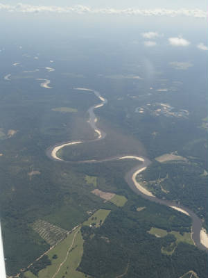 and relatively smooth. Wild Mama was running good although a bit warmer than normal. We made it to Sherman, TX (KSWI)
before 1800 local time. As we approached the airport for a landing on runway 34, we were greeted with the compass rose painted
by the Dallas 99s in 1997. The rose was still brilliant and was a welcoming reminder that no matter where we go, we can feel
the influence of the 99s and share their spirit of adventure. We felt right at home. We were met by John Hooker (J & S Aviation) who greeted us and gave us a map and the courtesy car for our ride into town where we will remain the night. Other than
being a great, friendly place to stop, they were the best fuel price int he are at $4.58/gallon!! and relatively smooth. Wild Mama was running good although a bit warmer than normal. We made it to Sherman, TX (KSWI)
before 1800 local time. As we approached the airport for a landing on runway 34, we were greeted with the compass rose painted
by the Dallas 99s in 1997. The rose was still brilliant and was a welcoming reminder that no matter where we go, we can feel
the influence of the 99s and share their spirit of adventure. We felt right at home. We were met by John Hooker (J & S Aviation) who greeted us and gave us a map and the courtesy car for our ride into town where we will remain the night. Other than
being a great, friendly place to stop, they were the best fuel price int he are at $4.58/gallon!!June 5th: Sherman, TX to Santa
Fe, NM: The weather looked menacing for a brief time when we awakened at 0530 this morning. There was a large
area of disturbed weather directly in our route of flight. We proceeded to get ready for departure and kept our eyes on the
radar for an anticipated 0830 departure. By the time we were ready, most of the 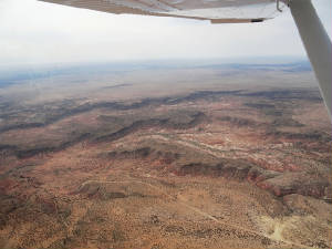 disturbed area had moved toward Wichita Falls, north of our flight path, making for a good looking ride. disturbed area had moved toward Wichita Falls, north of our flight path, making for a good looking ride.We departed on schedule, making a rather steep turn out early from KSWI, disagreeing with their suggested 260 heading and opting for the more conservative 240 heading to avoid the class D airspace immediately to the north. We climbed out to 10,000' and settled in. Ordinarily, I would be significantly lower, but by the time we get near Santa Fe, the MEA is right there at 10,000' so we have to get there sooner or later. We had some high clouds but nothing to get all excited about until just west of Hereford when we hit the very thin but very wet overcast layer. We broke out just before Hereford. We watched as the small towns and objects below us gradually grew bigger. When we emerged on the other side of the Texas panhandle, the ground was noticeably closer. The craggy landscape was deceptive and inched its way closer to us unsuspecting pilots. We passed the caprock dotted with windmills. The scenery changed dramatically from greens to a mix of light browns and light greens to a kaleidoscope of rust and reds as we crossed over Tucumcari. By now the hazy of the eastern US was disappearing behind us and the boundless skies open up before us. The mountain lay out ahead in the distance with little "teaser mountains" springing up all around us. This is Ellen's first time ever out here and she and I were enjoying the dramatic changes in scenery from lush green palm trees and endless miles of flatlands. We crossed a golf course west of TCC, the greenery looking grossly out of place. The temperature plummeted to 46 degrees and we pulled on the heat. We had been experiencing the "fuzzy feeling" of happiness but there was no joy on the warmth. 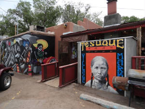 At 111 nm and 45 minutes out from Santa Fe, Albuquerque Center called with our arrival instructions to check ATIS and requested
our desire for an approach. This was a bit strange so we queried ATC that he, in fact, had our destination as KSAF. He was
just getting ready ..... and I thought I did things early! It must have been either our blazing ground speed of 143 kts, the
fact that he is incredible bored (the radio was relatively quiet), or the total lack of any small planes coming through this
neck of the (lack of) woods and he was accustomed to planes traveling at a MUCH faster rate. At 111 nm and 45 minutes out from Santa Fe, Albuquerque Center called with our arrival instructions to check ATIS and requested
our desire for an approach. This was a bit strange so we queried ATC that he, in fact, had our destination as KSAF. He was
just getting ready ..... and I thought I did things early! It must have been either our blazing ground speed of 143 kts, the
fact that he is incredible bored (the radio was relatively quiet), or the total lack of any small planes coming through this
neck of the (lack of) woods and he was accustomed to planes traveling at a MUCH faster rate.By the time we hit 35 nm out from Santa Fe, we got the ATIS and were ready for our visual approach. We really just forgot about the approach and concentrated on the spectacular scenery with the mountains coming clearly into view. Our next radio call was that we were to report airport in sight …. Wait a minute … we are here already???? We identified the airport, switched to tower and made a rapid descent on our downwind to runway 20. We secured our ride and headed off to lunch at Tesuque Village Market where we enjoyed some authentic local foods. We sat outdoors and watch the cottonwood trees drop their “snow” on the surrounding area. 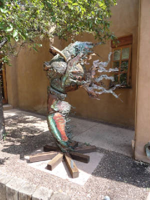 After lunch we headed out to downtown Santa Fe and on to Canyon Road where the local artists displayed their works. The variety of the art works was amazing – native works, contemporary works and antiques. We wandered about the city for the better part of the afternoon before calling it a day. We need rest for tomorrow when we head to Canyonlands, UT for a few days and we are still acclimating to the altitude. It will be an early start as we want to do some flight seeing and will have to be on the ground before the winds pick up at noon. June 6th: Santa Fe to Canyonlands National Park: Our
departure from Santa Fe was a hoot. Seems Becky from FMY called her friend Bruce on the tower at SAF to give us a
 "proper send off". Once again we were released for departure as Classic Racer 11 and given a send off proper for
a racer. Thank you Becky and Bruce!! We departed to the north to avoid the fire TFR to the west, which was a shame as there
was a caldera we wanted to over fly. But our route was spectacular none-the-less. We started over Abiqulu Lake and headed
westerly through the pass north of the San Pedro Mountains and south of Capulin Peak. We remained high - about 9,500' as parts
of our trip would require the altitude and we just assumed to stay up there so we could "proper send off". Once again we were released for departure as Classic Racer 11 and given a send off proper for
a racer. Thank you Becky and Bruce!! We departed to the north to avoid the fire TFR to the west, which was a shame as there
was a caldera we wanted to over fly. But our route was spectacular none-the-less. We started over Abiqulu Lake and headed
westerly through the pass north of the San Pedro Mountains and south of Capulin Peak. We remained high - about 9,500' as parts
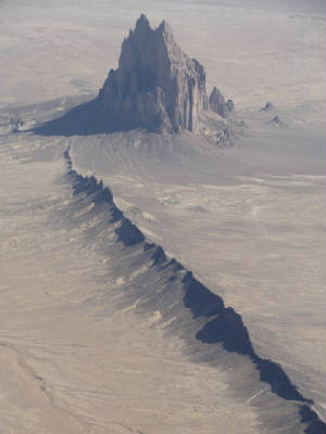
of our trip would require the altitude and we just assumed to stay up there so we could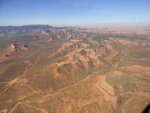 enjoy the rocks but not be too up close and personal. enjoy the rocks but not be too up close and personal. Our first point of interest was Pueblo Bonito a great house in the Chaco Cultural Nation occupied between 828 and 1126 AD. All of the rock formations were varied and interesting and amazingly different with every turn of the head. Ellen and I each had very different views and a look backward produced even more variations. Our next fly over was Ship Rock. The peak and surrounding land are of great religious and historical significance to the Navajo people. It is mentioned in many Navajo myths and legends. Foremost is the peak's role as the agent that brought the Navajo to the southwest. According to one legend, after being transported from another place, the Navajos lived on the monolith, "coming down only to plant their fields and get water."[7] One day, the peak was struck by lightning, obliterating the trail and leaving only a sheer cliff, and stranding the women and children on top to starve. The presence of people on the peak is forbidden "for fear they might stir up the ghosts, or rob their corpses." (from Wikipedia). 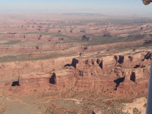 Past Shiprock we headed northwest toward Monument Valley. The flight leading up to Monument Valley was almost as spectacular
as the Valley Past Shiprock we headed northwest toward Monument Valley. The flight leading up to Monument Valley was almost as spectacular
as the Valley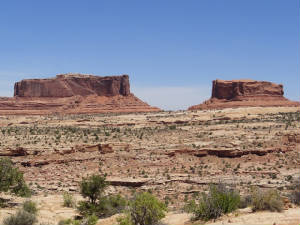 itself, dotted with towering monoliths. We flew between so we could each get a great view of totally different features -
it was a debate as which was the better side! From there, it was north toward Canyonlands/Moab Airport. We flew over the Comb
Ridge and remained just east of Canyonlads National Park. The sights of Canyonlands were amazing: the crevices, layers of
colors and unique rock features. There were sections resembling a "Dagwood Sandwich". We dropped over the ridge
and in to the valley to approach KCNY. Even though the winds were light, Wild Mama was still rocked quite a bit but
the ride was good all and all. itself, dotted with towering monoliths. We flew between so we could each get a great view of totally different features -
it was a debate as which was the better side! From there, it was north toward Canyonlands/Moab Airport. We flew over the Comb
Ridge and remained just east of Canyonlads National Park. The sights of Canyonlands were amazing: the crevices, layers of
colors and unique rock features. There were sections resembling a "Dagwood Sandwich". We dropped over the ridge
and in to the valley to approach KCNY. Even though the winds were light, Wild Mama was still rocked quite a bit but
the ride was good all and all. Parking Wild Mama, we dashed off to the National Park, oooohing and aaaaahing all the way. We stopped at the Monitor and the Merimack formations, Mesa Arch , the Grand View Point Overlook, Buck Canyon Overlook, Upheaval Dome and many others until ....... 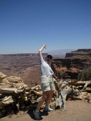 ..... just kidding. No racers were injured in the making of this journey. Santa Fe to Canyonlands National Park photos June
7th - Arches National Park: Moab is an interesting little town. Most everything in centered on or around Main
Street. The other streets are labeled in relation to Main Street – 100 North, 300 East, etc. – so it is relatively
easy to find your way around if you have a street address. As we came into town yesterday we could see the bustle of activity
 on Main Street at the many shops, restaurants and adventure centers. A quick exploration journey lead us not too far in either
direction off of Main Street because of the mountains – the city is stuffed in between them and really has no place
to grow. We did manage to find a decent Chinese restaurant for dinner. on Main Street at the many shops, restaurants and adventure centers. A quick exploration journey lead us not too far in either
direction off of Main Street because of the mountains – the city is stuffed in between them and really has no place
to grow. We did manage to find a decent Chinese restaurant for dinner.In trip planning, we suspected that the town was not very large and there are really no other options if you cannot locate a place to stay in Moab so 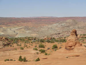 we decided to pre-book a room and found the on-line “pickins” slim. We secured the Silver Sage Inn – one
of the lesser expensive but we had few choices. As we passed hotel after hotel with vacancy signs we knew we could have done
this without a reservation. I note that the Holiday Inn Express touted a $300 nightly rate on-line. Our hotel was at the far
south end of town and we were beginning to wonder if it was the kind where you pay by the hour. We finally arrived at the
sensational Silver Sage Inn. We were completely underwhelmed by the outside appearance – small, no frills and few cars
in the parking lot. We checked in to our “superior” room and much to our surprise and delight, it was quite adequate
for our needs: the rooms was clean and of sufficient size; the beds were comfortable; we had a refrigerator, microwave and
coffee pot with coffee; we had ample A/C and hot water and a blasting shower pressure and the surroundings were quiet (no
loud parties, neighbors or traffic noise). Looks can be deceiving. Awake at 0530, we readied ourselves for
a long day at Arches National Park. This is one of the parks that has been on my hit list for a long time and the day has
arrived. The weather was cooler than expected – about 57 degrees – with an expected high of the mid-80s. we decided to pre-book a room and found the on-line “pickins” slim. We secured the Silver Sage Inn – one
of the lesser expensive but we had few choices. As we passed hotel after hotel with vacancy signs we knew we could have done
this without a reservation. I note that the Holiday Inn Express touted a $300 nightly rate on-line. Our hotel was at the far
south end of town and we were beginning to wonder if it was the kind where you pay by the hour. We finally arrived at the
sensational Silver Sage Inn. We were completely underwhelmed by the outside appearance – small, no frills and few cars
in the parking lot. We checked in to our “superior” room and much to our surprise and delight, it was quite adequate
for our needs: the rooms was clean and of sufficient size; the beds were comfortable; we had a refrigerator, microwave and
coffee pot with coffee; we had ample A/C and hot water and a blasting shower pressure and the surroundings were quiet (no
loud parties, neighbors or traffic noise). Looks can be deceiving. Awake at 0530, we readied ourselves for
a long day at Arches National Park. This is one of the parks that has been on my hit list for a long time and the day has
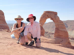
arrived. The weather was cooler than expected – about 57 degrees – with an expected high of the mid-80s.We dashed off to Arches National Park. On a beautiful day like this the Park should be crowded. We wanted to get some hiking in before the heat of the day hit and before the height of the crowds hit as well. After a brief stop at the Visitors Center we headed to take the 2.5 mile long Delicate Arch hike. It was said to be an “easy to moderate hike” but 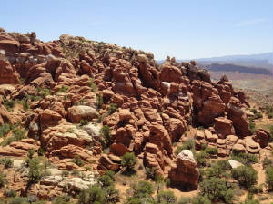 that there is a point at which you wonder if you will ever get there. that there is a point at which you wonder if you will ever get there. The initial part of the trail was easy, well marked and not crowded. There were a few inclines but we were to make an overall ascent of 500’ so this was not a big deal if the inclines were like the ones at the beginning. We queried a gentleman walking down and he indicated that “once you get over the rock you are almost there”. We saw the rock ahead … it was rather large. We started our assault on the rock. This was no longer an easy hike; in fact, I am not so sure that I would call it a moderate hike. Parts of the rock were quite steep. It was a long stretch and we were, indeed, wondering if we would ever get there. But the rewards were worth the effort. After round the ledge high above the Park floor below, we saw the Arch, towering and majestic as a sentry over the Park. There was a butt slide to get to the rocks where you could walk down to the Arch to get the best photo and another rock scramble to see the back side of the Arch area. Each view was more spectacular than the last. I made the rock scramble while Ellen waited below. As I slid back down the rock to her level, my water bottle popped out of my pocket ad slid down the rock at a much more rapid pace than I. Another visitor, Ray from Wisconsin, ran down the rock to get the bottle – my hero – while wearing cowboy boots! After a brief time admiring the view it was time to head back and watch the next set of visitors huff and puff their way to the top. Our next stop was to see Fiery Furnace, Landscape Arch, Tunnel Arch and Pine Tree Arch (aptly named for the pine tree growing in the middle of the Arch. The hike was much 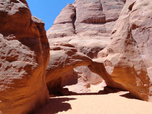 easier, except for the sand portion as we approached Landscape Arch, and the views were all equally as spectacular. Sand
Dune Arch lead us through a small slot canyon to an arch resembling the head of a raven but the sand was more akin to walking
along the beach. easier, except for the sand portion as we approached Landscape Arch, and the views were all equally as spectacular. Sand
Dune Arch lead us through a small slot canyon to an arch resembling the head of a raven but the sand was more akin to walking
along the beach. The afternoon wore on and so did we and we opted for some overlooks and VERY minor hikes as the temperatures hit the low 90s and we grew more tired. The Windows, Double Arch and a few minor “arches in progress” were all we had the strength to walk to; then a quick stop at Balanced Rock and call it a day. 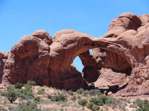 We make a more extended stop at the Visitors Center on the way out where Ranger Lee helped us with some plant identification.
Throughout the park we admired the subtle changes of the landscape collation from the vivid blue skies to the iron and rust
colored rocks that morphed into a sea of yellows blending in a rainbow of greens. We could identify the Silver Sage but he
added the Mormon’s Tea, Salt Bush, Buckwheat varieties, Drop Seed, Rosen Bush, Cliff Rose, narrow leaf yucca, Utah Juniper,
Snake Weed, Prickly Pear, Welshes Oak, Rabbit Brushes and other grasses that are so vital to the survival of the fragile ecosystems
in the Park. We make a more extended stop at the Visitors Center on the way out where Ranger Lee helped us with some plant identification.
Throughout the park we admired the subtle changes of the landscape collation from the vivid blue skies to the iron and rust
colored rocks that morphed into a sea of yellows blending in a rainbow of greens. We could identify the Silver Sage but he
added the Mormon’s Tea, Salt Bush, Buckwheat varieties, Drop Seed, Rosen Bush, Cliff Rose, narrow leaf yucca, Utah Juniper,
Snake Weed, Prickly Pear, Welshes Oak, Rabbit Brushes and other grasses that are so vital to the survival of the fragile ecosystems
in the Park. It is time to relax and prepare for en early departure on Friday where we make the southerly run to Kanab, UT for the next part of our adventure. June 8th – Moab to Kanab: The day started very
early for us today. The winds were forecast to be high, picking up in intensity all day so we thought it best to be airborne
by The morning air was still and cool – only 56 degrees
– and in spite of density altitude, Wild Mama was flying great. We followed the highway back down to Moab as we climbed
out to 8,500’, then turned to the southwest-ish following the Colorado River on the east side of Canyonlads National
Park. We passed the lookout point where we had driven just 2 days before and saw the “back side” of the view:
still quite magnificent. Lighting plays an important part in mountain viewing – the brilliant colors of the high noon
sun were washed away with the morning but as the sun rose ever higher in the sky the kaleidoscope of colors started to return
from the tops downward. My job was fly, so Ellen go the “view” side of of the plane
and I paid attention to the River, meandering our say to the southwest. The winds aloft were already up to 18-20 kts (headwinds,
naturally) but the ride was mostly smooth with an occasional warble as we passed a high peak. In short order we had arrived
at Lake Powell and made the turn at Page, AZ for the last leg to the west toward Kanab. This route took us right over “The
Wave”, the rock formation that we had tried to get a hiking permit to see. The BLM only issues 20 hiking permits per
day for The Wave and you have to apply by lottery in February for a June permit. We were not successful in securing a permit
among the 1600 applicants for the 20 slots. But we had a back-up plan. Today, however, we get the aerial view. We got the
GPS coordinates and headed to the spot. You could see the swirls and the colors of Paw Hole for miles out. We circled the
area, Ellen snapping photos of all of the Wave-like features we could find. The Coyote Butte With SD cards chock full of photos, we made the last leg to Kanab where we landed on runway 1 with an ever increasing 5 kt wind. It was good to be on the ground: we had an outstanding flight but we know what is coming and we succeeded in beating the winds to Kanab. Our rental car place did not open until 0800 so we clean and cleaned out the airplane until it was time to call. We had reserved a 4x4 Jeep for the next few days as the terrain and the driving conditions on some of the roads to the trailheads can be a little slick or sandy. We had not anticipated such an early arrival so we had an extra day available to us, so to speak, and headed off to plan the day, deciding on Willis Creek Slot Canyon via Skutumpah Road (we called this “Stump the Chump” Road because half the time we were not sure where it was leading us). We
departed on highway 89 to the south, then north on Johnson and off into oblivion on Skutumpah Road. We were happy to have
the 4x4. The road quickly went from paved to smooth gravel to rumple strips the morphed into a sand pit as we started winding
our way down the mountain. We stopped at many points along the way for scenic views and to admire the many wild flowers that
are growing along the road. After passing the clay wash – deemed impassable if a rain storm would happen to come by
– we crossed Bull Valley Gorge We selected this slot canyon because it was billed as an easy kike as opposed to many that require ropes, carabineers and experience. They also billed this hike as “flat” but we quickly learned that “flat” from the perspective of a Utahan differs greatly than from that of a Floridian. We descended into the canyon to start the hike, following the creek the whole way – at least the trail was easy to follow. This slot canyon in not as skinny as many: in some spaces you could touch both sides of the canyon while in others we were able to walk side by side. The walls towered over us and we felt an instant cool down of about 15-20 degrees from the high noon heat of the day. You could imagine the effect of the water flowing over the rock for millions of years, ponding and pooling in places to produce a rounded hollowed look punctuated by sharper points. The lines and striations in the rock showed the geological history of the area and produced that Wave-like pattern but this time in shades of gray. Those interior rocks were quite cool to the touch in many places we could see layers of smaller rocks imbedded in the lines. We continued along in and out of small slot canyons until the creek
trickle into the sands and stopped. Rounding the bend, we saw an arch beckoning us to continue further down the trail to the
next canyon that seemed just a short walk away but we had already covered the roughly 1 hour we calculated to make the inward
portion of the hike and decided to turn back, lest we end up at the other end of a 13 mile one way path and far away from
our car with no cell phone In lieu of returning through the rumple strip road, we
opted to continue to Cannonville and onto the highway. We drove back up out of the canyon and then continued on a series of
ups and downs on a narrow, sandy path with a straight drop off to our right. I drove on the left to leave as much space as
possible between us and the canyon below, hoping that no cars were motoring the opposite direction. We crested one hill to
encounter a vast rainbow vista: a spread of greenery, the pink and yellow mountains lay against the brilliant blue sky. Quite
awesome to behold! We arrived back on a paved road to the south of Bryce Canyon national Park in a series of Parks and other
protected areas. Cresting another mountain the hoodoos came The stop was Mossy Caves and the hoodoo trail (our name because it was lined with hoodoos off in the distance). It was a magical area with a waterfalls, hoodoos and the only cave sporting humidity in the area – humidity sufficient to support the growth of moss in the desert. We pressed on up through highway 12 then made the loop back to highway 89 and back to Kanab. It was already 1800 and time for us to get some dinner ad rest. Dinner was at the Rocking V Diner, an interesting
restaurant with an upstairs art gallery with local art. We finally made it to the Quail Park Lodge for the evening, plunking
ourselves in our spacious retro-styled hotel room: very comfortable and very nice. We are tired after a long day and need
to rest to re-group for another exciting day tomorrow. June 9th – Toadstools, Grand Escalante, Best Friends:
We got a good night’s rest last night and had an easy day today. We got off just before 0800 to head off to the Grand The Center volunteers suggested taking route 89 south for some nice hikes and scenic drives so we said “why not” and set out to the east. The toadstools were the first hiking stop. This is considered back country hiking but at the mildest form. Good thing. The trail lead through the wash and appeared to be pretty easy until we hot 2 dead ends following the foot prints in the sand. We could see where we needed to go but did not see the most obvious path to get there until we spied the 81 year old man on top of the toad stool mound and hollered up to him to point to the trail. Seems his family made the same error and it was their foot prints we followed. The toadstools were interesting formations that we dubbed “hoodoos in training”. They look, well, exactly like toadstools or mushrooms. There were several varieties in shades of whites and reads. Having our fill of toadstools, we wandered back out to the car to head out on Cottonwood canyon Road, said to be an exquisitely beautiful drive. It did not take us long to realize that following this road to its ultimate destination would leave us insufficient time to make it to the Best Friends tour scheduled for 1500 this afternoon so we abandoned the mission and opted for smaller and lesser dirt roads on the way back along highway 89. We found Paria Township Road/585. This road was to hook to 584 and loop back out to highway 89. We entered into a small valley then popped up over an embankment to see an array of colors the likes of which we had not seen to date. There were more hues of greens and browns mixed beneath a rainbow of compressed layers. None of this was visible from the highway in spite of our being within a stone’s throw. We 4 wheeled our way around until we hit a point of 584 where the rocks in the road looked somewhat bigger than the eight of the undercarriage of the Jeep so we did a 180 and headed back to the highway for the trip back to Kanab. The Grand Staircase Escalante, we learned, is a series of plateaus formaing a staircase. The lowest level is the chocolate (where Kanab sits), then vermillion, white, gray and pink on top where Bryce Canyon is located. The area is rich with vast, still unexplored wilderness areas. We only scratched the surface. Our final planned activity for the day was Best Friends Animal Sanctuary and Rehabilitation Center. The facility sits on 3700 of their own acres Our unplanned stop was to the cave and hidden Lake on the
Best Friends property. We hiked back about 1 mile or so to a shallow cave with a hidden lake inside. The rocks were very Wave-like
and the smell of moisture and the cool temperature in the cave were enchanting to us humidity dwellers. After this full (easy
day for 2 “type A’s), we headed back to prepare for a full
Toadstools, Grand Escalante, Best Friends Photos June 10th - Bryce Canyon: Bryce Canyon has been on my gotta do list for years, and today I got er done. Ellen and I took the most popular hike in the park, the Queens/Navajo Loops trails: a 3 mile hike from the rim down to the bottom of the hoodoo spires over 600' below.
We headed back to the hotel
early to get some rest for tomorrow when we do our hike in the Coyote Butte South area. Passing by the small towns heading
south along Highway 89 we encountered the same local Sheriffs sitting along side of the road and thought this odd that
they always seemed to be there. As we passed the last spot we recalled seeing the Sheriff on our northbound trip we slowed
to take a good ander inside the car only to find a dummy cop posed behind the wheel. How incredibly genius - slowing the tourists
and saving the taxpayers bundles for salaries! June 11th - Coyote Butte South:Today was the big day.
Ellen and I have been training for this hike for nearly 8 months when we decided to do it. This was the hike in the back country
in the middle of the dessert in the middle of the summer. But the Gods were shining down on us and the temperatures today
did not reach the scorching 110-120 that is
 common. We started the morning at 52 degrees and were quite cool but we knew we wold be heating up soon enough. We met Steve
Dodson of Paria Out Post at 0800. Steve was our guide to the back country to get us in and out safely and get us to the good stuff as expeditiously
as possible. common. We started the morning at 52 degrees and were quite cool but we knew we wold be heating up soon enough. We met Steve
Dodson of Paria Out Post at 0800. Steve was our guide to the back country to get us in and out safely and get us to the good stuff as expeditiously
as possible.A college economics student and her 85 year old grandfather were the other hikers on this jaunt. Steve packed us all in his Suburban and hauled us  off to the trail head about 1-1/2 hours down a dusty and bumpy road that made the rumple roads that we had traveled look
like super highways. In short order we were loading up our lunches and water an set off up the sandy hill. We had about 20
minutes of a deep sand hike and the sand was kicking my butt. I stayed in Steve's footprints to minimize the amount of work
that I had to do. But as we crested the hill the scene that I have waited to see for a long, long time came in to view. While
we were not successful in obtaining their permit for the Wave, the Coyote Butte area to the immediate south - and in full
view of the Wave - was unparalleled in its awkward beauty. There were many Wave-like formations; rocks that had been twisted
and contorted with time in a painful tangle of colors; there were "bee hives"; there were fragile sand stone "paper
stacks" all of varying hues from the off to the trail head about 1-1/2 hours down a dusty and bumpy road that made the rumple roads that we had traveled look
like super highways. In short order we were loading up our lunches and water an set off up the sandy hill. We had about 20
minutes of a deep sand hike and the sand was kicking my butt. I stayed in Steve's footprints to minimize the amount of work
that I had to do. But as we crested the hill the scene that I have waited to see for a long, long time came in to view. While
we were not successful in obtaining their permit for the Wave, the Coyote Butte area to the immediate south - and in full
view of the Wave - was unparalleled in its awkward beauty. There were many Wave-like formations; rocks that had been twisted
and contorted with time in a painful tangle of colors; there were "bee hives"; there were fragile sand stone "paper
stacks" all of varying hues from the 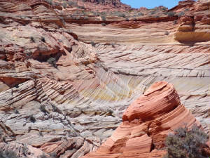 pastel pallet to the deep rusty formations filled with iron. pastel pallet to the deep rusty formations filled with iron. We wandered about for the better part of 5 hours up over the rock, through the south Wave; passing Raven's Nest Rock; two-tone rock and Salvador Dali rock. We were all awe-struck and oooooo, ahhhhhh and wow were common terms heard throughout the afternoon. Steve showed us some of his special treasures hidden to protect them from those who may not respect the area and the rules. Steve had some arrowheads and a section with dinosaur tracks embedded in the sandstone bed. 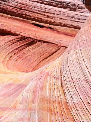 As the temperatures soared to the low to mid 90's it was time to start heading out. Steve directed Ellen and I to the top of a rock that gave us one last lingering look at this Coyote Butte area. I have wanted to be here for years and the day came; the day was thoroughly enjoyed and these memories will be treasured for life. Thanks to Steve and Paira Outposts for an awesome day. There are insufficient words to describe this unique area so the best I can do is share the photos. June 12th - Kanab - Grand Canyon - Sedona:
We are inching ever closer to the start of the race in Lake Havasu, meaning that our pre-race adventure is coming to an end.
Our destination today is Sedona, AZ, an easy 30-40 minute flight that will take us about 1-1/2 hours ... the indirect route,
of course. We departed at first light again with the winds
 forecast to be high this afternoon. The METAR said "light and variable" but it did not quite feel that way to us.
The thermometer on the bank indicated 61 degrees but the wind chill was 36 degrees. You do the math but I can tell you that
it was darn cold. forecast to be high this afternoon. The METAR said "light and variable" but it did not quite feel that way to us.
The thermometer on the bank indicated 61 degrees but the wind chill was 36 degrees. You do the math but I can tell you that
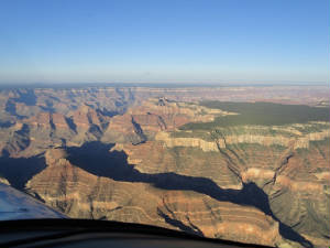
it was darn cold. We made a southerly downwind departure to avoid the rocks at the north end of the runway. It made the climb out much more secure and less standing on our tail. The first fly over was of the Coyote Butte area again. Now that we can identify the Wave, we want to see it from the air for certain. We made the beeline to the area and found the Wave right away. We circled for a minute only to be thoroughly convinced that the south area has far superior scenery: the colors are more vibrant, the rock formations more diverse and the area much larger and "worth the hike". Satisfied, we left, waiving good-bye to Utah and focusing on our climb to 10,500' to make our Grand Canyon overflight. We did not want to dawdle the day away so we chose a limited viewing are of Marble canyon and the Zuni Corridor. The morning sun cast eerie shadows on the east facing rock crevices while illuminating the prominent rock faces. The colors were so different from the sand stone formations we visited the day before even though the location was less than 30 miles away. We passed over Marble canyon airport and made the turn to the south meandering along with the Colorado River until our first Grand Canyon "stay out of the no fly zone" way point. Engaging the 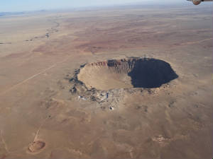 autopilot and GPS steering, we made sure that we would not wander off course as our eyes wandered all over the canyon. We
exited the south rim and made the turn back to the east for Sunset Crater and Meteor Crater as we started our descent back
to earth. autopilot and GPS steering, we made sure that we would not wander off course as our eyes wandered all over the canyon. We
exited the south rim and made the turn back to the east for Sunset Crater and Meteor Crater as we started our descent back
to earth. Skirting Humphrey's Peak, we saw a large lava field. The landscape in this region is very different again from the area in the Vermilion Wilderness Area and again from Bryce and the whole Grand Staircase Escalante plateaus. The earth was scarred with the markings of craters - from volcanic origin or from space, the Meteor Crater being the largest in the area. After passing Meteor Crater, we crossed a lush fertile valley as we made the  final descent to the plateau just northeast of Sedona. final descent to the plateau just northeast of Sedona.The Sedona Airport sits on top of a mesa and resembles the shape of an air craft carrier. Althouth you can use either runway, pilots are much advised to land on runway 3 and depart on runway 21 because of the up sloping runway but more importantly becasue of that plateau that we were crossing. The term "rapidly raising terrain" comes to mind. We descended as far as we could until the last of the M20 colors below us turned to red and the 496 (whom we call "Betty") started chanting "Terrain, terrain - pull up, pull up." W were pointing nearly straight to the ground to try to make the "recommended" 3,500 fpm descent in time for our downwind entry to runway 3. We throttled back and weaved in and around the rock formations and swung a wide downwind leg to finish losing altitude as we entered the pattern. We heard Hal and Vern on the radio arriving in the Skylark that Vern and I delivered to Hal back in October. They were joining us for breakfast at the Mesa Cafe. Hal has not done too much mountain flying and he was taking advantage of Vern's time in Phoenix to get some flying time in and to learn how to use the iPad for mountain flying so he 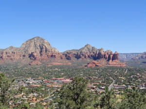 could venture out farther on his weekly joy-flights. Ellen and I told the boys of our adventures and the overflight, encouraging
them to fly up to Kanab to see the town and the Grand Staircase Escalante plateau area. We left them with our iPad GPS
and the Grand Canyon chart and bid them farewell as they flew off for more fun. As for Ellen and me, we will be here for a
couple of days unwinding and re-introducing ourselves into civilization. could venture out farther on his weekly joy-flights. Ellen and I told the boys of our adventures and the overflight, encouraging
them to fly up to Kanab to see the town and the Grand Staircase Escalante plateau area. We left them with our iPad GPS
and the Grand Canyon chart and bid them farewell as they flew off for more fun. As for Ellen and me, we will be here for a
couple of days unwinding and re-introducing ourselves into civilization.We wandered about town for the better part of the morning and into the early afternoon until our hotel room was ready. We packed for a hotter than blazes trip and we finally got it, ditching our jackets and long sleeved shirts. We will take it easy this afternoon and plan for our last full day of vacation tomorrow, then off to Havasu on Thursday where it's all business for the race. Kanab to Sedona via Grand Canyon Photos June 13th - Sedona: Our last day of vacation was another
fun and easy day. We started with a bird watch hike through the Red Rock Canyon State Park. The setting was peaceful and the
birds were plentiful. After the hike, we headed off to the Slide Rock State Park for a little fun. Seems there is a "slide"
naturally cut in the rocks. It is a very popular
 summer hang out and great refuge from the heat. What I did not kow was that the water was a bone chilling 63 degrees. I walked
along the rocks to get to the start of the slide and jumped right in. It was ike jumping in to an ice bucked but it was too
late - I was heading down the slide, goosebumps and all! It was still a blast and with the mid to upper 90s temperatures baking
the area, it was quite refreshing and I warmed up quite quickly: enough so that I hit the slide twice more before calling
it quits. summer hang out and great refuge from the heat. What I did not kow was that the water was a bone chilling 63 degrees. I walked
along the rocks to get to the start of the slide and jumped right in. It was ike jumping in to an ice bucked but it was too
late - I was heading down the slide, goosebumps and all! It was still a blast and with the mid to upper 90s temperatures baking
the area, it was quite refreshing and I warmed up quite quickly: enough so that I hit the slide twice more before calling
it quits. The remainder of the afternoon we spent wandering around the lower part of the City and taking int he tourise sites and doing the last of our vacation shopping. We are back at the hotel early to pack one last time and ready ourselves for the race. Havasu: Here we come!!! June 14th - Sedona to Lake Havasu, AZ: By the time we
departed at 0700 this morning, the winds we alreay picking up a little bit but still a beautiful day to fly. We headed west
with the goal of Lake Havasu City in a short hour. But we have not come all this way to stop just short of California so we
decided to make a true cross country and diverted to
 Needles, CA, just so we can say we made the full trek. Needles, CA, just so we can say we made the full trek. The scenery through most of this leg was unremarkable compared to the vivid colors that we had left behind. We had one more mountain to clear before our descent to Needles. We had about 14 kts of wind on the ground and quite a bit of a crosswind in the air; but we made our call in to Needles and plunked down on runway 20. The airport was quiet. We were looking for some sign to direct us to the ramp area; some activity; some sign of life. There was none. As we made our way to the ramp there was a series of dilapidated buildings and 2 lone airplanes. None of the shade hangars were in use. The airport looked like an area that time forgot. As we jumped out of the airplane we were greeted by a huge Jack Rabbit and and covey of quail. Had it not been for the cooing of the quail, stark silence would have greeted us as well. Our goal here was to snap a photo of us in  front of The Needles Airport sign. No such luck. The best Ellen could find was a guest book where the last entry was 10 days
prior to our arrival. We snapped a photo there and in front of some sage brush that is bound to become a tumbleweed in time
to come. The experience was sureal. front of The Needles Airport sign. No such luck. The best Ellen could find was a guest book where the last entry was 10 days
prior to our arrival. We snapped a photo there and in front of some sage brush that is bound to become a tumbleweed in time
to come. The experience was sureal.We fired up Wild Mama and headed southeast for Lake Havasu City. We remained relatively low through the pass and down the river to the airport and were greeted by a 14 kt and very warm wind blowing straight down runway 14. We were greeted by Vern, "Team Mama Bear" and the other  ladies of the 99s at Havasu who have worked so hard these last months preparing for the arrival of the races. Classic 50 had
already arrived but was not yet on the ramp so Wild Mama was sitting all alone in the tie down area. Our only activity
for the day was to arrive, check in to the house and get an oil change on Wild Mama. She has flown another 20 hours now en
route from FL to the race start and we wanted to make one last check of the oil filter for signs of metal. Arizona Aircraft
Maintenance pulled her in the hangar, changed the oil and cut open the filter. Clean as a whistle! ladies of the 99s at Havasu who have worked so hard these last months preparing for the arrival of the races. Classic 50 had
already arrived but was not yet on the ramp so Wild Mama was sitting all alone in the tie down area. Our only activity
for the day was to arrive, check in to the house and get an oil change on Wild Mama. She has flown another 20 hours now en
route from FL to the race start and we wanted to make one last check of the oil filter for signs of metal. Arizona Aircraft
Maintenance pulled her in the hangar, changed the oil and cut open the filter. Clean as a whistle! Tomorrow will be another day but we are done for today. It is 98 degrees at 1100 local time. We will get some groceries, have lunch and rest .... needing to do some of the more mundane things like laundry and sorting out our stuff. OK .... so we made a small outing this evening across the Lake to the Havasu Landings Resort. There was a coupon for a free ferry ride and 10% off dinner - who could resist. Sedona to Lake Havasu via Needles Photos June 15th - Inspections: Ellen and I were at the airport
promptly at 0600 ... OK, a little before 0600. We were meeting the detailer to wash Wild Mama as her belly was pretty
dirty from the long flight out here. with the detailing completed it was time for inspections. Wild Mama was called
in at 0730. I removed the cowling and watched as the inspectors
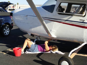 poured over the log books and checked her out from stem to stern. Twenty minutes later she got a clean bill of health
and we taxied her back out on the line and "tucked her in" for the next few days. She is impounded now and we cannot
have any contact with her until race morning. poured over the log books and checked her out from stem to stern. Twenty minutes later she got a clean bill of health
and we taxied her back out on the line and "tucked her in" for the next few days. She is impounded now and we cannot
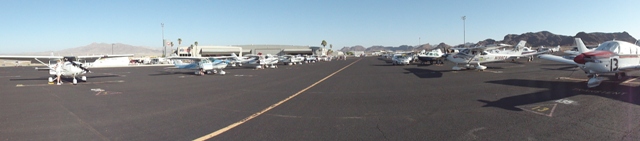
have any contact with her until race morning.Racers were arriving by the minute now and the airport was abuzz with activity. The Flyin Hawai-Iowans were debugging; the N'oreasters already 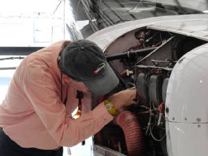 flew their numbers off and were working on new numbers, L'il Red was being inspected. Many other teams were washing and cleaning
out the planes. flew their numbers off and were working on new numbers, L'il Red was being inspected. Many other teams were washing and cleaning
out the planes.Our next stop was credentials where our personal log books, pilot certificates, currency, etc. is checked. Ellen had everything but her BFR paper so she got husband, Ed, to fax it over promptly and we were released as properly credentialed. We headed off to the hotel for start registration, gathering our name tags and race information. The Rio Colorado 99s have done an outstanding job on everything and the hospitality suite was first rate. Today was a very easy day, Ellen and I needing to rest and work on race stuff so we hung at the house, commiserated and took an evening walk once the temperatures dropped below 100. Inspection & Credentials Photos June 16th - la Fiesta:There is a big advantage of getting
to the race start early: you get your work completed early then have time to enjoy the local scenery. We located the Havasu
Wildlife Preserve just north of Havasu and close to Needles. We ventured out early to do some more bird watching and take
a hike through the preserve. While the bird
 watching pat was not as fruitful as we had hoped, we thoroughly enjoyed the easy hike. watching pat was not as fruitful as we had hoped, we thoroughly enjoyed the easy hike.We were excited to see the remainder of the Town of Needles, CA, having seen not too much from the air but certainly curious after our underwhelming stop at the Needles Airport. Apparently, Route 66 passes through Needles and we were tickled to see the nostalgic signs or this 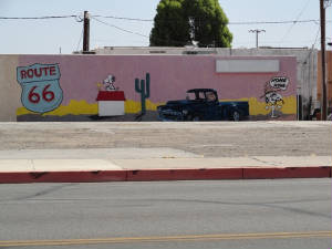 historic highway and stopped to snap pictures wherever we could. We departed town through the Mojave Desert heading south
on 95 to Parker. It was obvious that we were now in California: gasoline was $3.51 just outside of the Wildlife area but was
a whopping $4.59 once we rossed the border. Yikes!!! We stopped for lunch at the Crossroads Diner in Parker and felt we were
thrown back into the 60's - even the ladies room had a psychedelic paint scheme. historic highway and stopped to snap pictures wherever we could. We departed town through the Mojave Desert heading south
on 95 to Parker. It was obvious that we were now in California: gasoline was $3.51 just outside of the Wildlife area but was
a whopping $4.59 once we rossed the border. Yikes!!! We stopped for lunch at the Crossroads Diner in Parker and felt we were
thrown back into the 60's - even the ladies room had a psychedelic paint scheme.The afternoon was spent visiting the racers in the hospitality room and relaxing before the evening Fiesta at the Hampton Inn. Once again, the Colorado Rio 99s outdid themselves on the event - a full buffet of Mexican fare complete with apple burritos for dessert - I went straight for dessert. Our whole race family was there. AC has a system of "Mother Birds" - experienced racers who help the first time racers or "Bay Birds". Our babies this year are Jessica and Jessica (Classic 57), a collegiate team from LA Tech. We had dinner with them and our original Mother Birds, the Carastro's. Unbeknown to us, Tookie Hensley was the Carastro's Mother Birds so she is my racing "Grandma". The "Family photo" consisted of the 4 "generations" of racers. We hope the family will continue to grow. 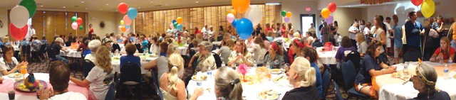 Our first brieings are tomorrow and we hope to get the handicap numbers. There are several that have to be re-flown because of bad date, density altitude too high, etc. We anxiously await our number... June 17th - Briefing and Banquet:This was a slow day
for us. The better part of the morning was spent in the all racers briefing where we got good general information about flying
the race, what to expect and various things to consider abut race flying - care and feeding of aircraft and pilots especially.
We had an afternoon lunch with Classic Racers 21 and 23 and hung out at the hospitality suite awaiting the arrival of handicaps
that never materialized. With a few hours until the banquet, we gave up and headed back to the house.
The start Banquet was a wonderful affair. Jennifer Wade, an F16 fighter pilot was the guest speaker. She was quite entertaining and talked about her experience in Iraq and about being a female in an otherwise all male squad. ARC President, Marolyn Wilson, concluded the program with the introduction of racers - basically roll call where we get our participation charms. Tomorrow will be the remainder of our briefings and hopefully the news of our handicap speed. June 18th - Making Segway: Today was slated to be a long day of briefings and the Carastros and Team Wild Mama decided to head out for a little R & R before the long sit. We took a Segway tour of Havasu City. Our guide started us in a large parking lot so we had some time to acclimate to these interesting creatures before he turned us loose on the sidewalks of Havasu. Marie went first and took to the Segway almost immediately. She went zooming off in the parking lot hollering "Look, no hands!!!" Once the rest of us got checked out on the equipmnt we headed off for a great 1-1/2 hour tour of Lake Havasu City and the parks along the lake. 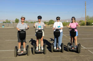 The remainder of the morning was briefings: fly-bys, weather and safety. Also, the infamous handicap sheet came out and Wild Mama got 160.50 kts. While this is 4 kts higher than last year, it was not a surprise: with the new paint, wing tips and the repairs, plus one less team member and an completely empty plane. Ellen ad I came back to the house to finish packing and making all the briefing notes on our Navigation Log. We must relax, rest and (if Stubby were here) pet the kitty so we are ready for the big day tomorrow. stay tuned. The race is about to begin! June 19th - Race Day 1:It is finally here. After another
year of preparation the big day is upon us. All the racers are up and ready to go: first breakfast then the last weather briefing
then the mad dash to the airport. Everyone was nervous and you could feel the tension in the air. The tailwinds were forecast
so we were happy but the first 2 legs through the mountains were going to be tough. Many of the racrs flew these legs backwards
getting to the race but that is something that I prefer not to do. I like the thrill of first impressions. The Colorado Rio
99s were the greatest - very organized and the start was a well run event. Getting the racers off the ground was no exception.
The first plane launched at 0800 sharp and we followed in a few short minutes. We waived goodbye to the forecast 117 degrees
of Havasu as we headed out over the mountains.
 The first leg took us over the painted desert. The canvas of pinks was a beautiful sight to see, especially in contrast with the browns all around it. It has been a while since we say actual grass that we were beginning to wonder if it still existed. We settled in to an easy leg and prepared for the flyby at Gallup. We had passed most of the racers except Classic 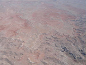 2 - also flying an RG, We heard her flyby call and she got in the pattern to land as we made our pass. We made a flyby to
continue and Classic 24 (Cirrus SR 22) was hot on our tail, making a flyby to land. We zoomed past the runway, made the turn
to the east and were staring at a TFR that popped up right in front of us. Ellen got the altitudes and it was surface to 1500'AGL.
We were very close to the south side of the TFR but could not deviate south because of a restricted area so we stood Wild
Mama on her tail and climbed over the top clearing the airspace without a problem. Whew, that was close! We hope the racers
behind us had the same climbing capacity or that the TFR was not active - we had no time to look for hours. 2 - also flying an RG, We heard her flyby call and she got in the pattern to land as we made our pass. We made a flyby to
continue and Classic 24 (Cirrus SR 22) was hot on our tail, making a flyby to land. We zoomed past the runway, made the turn
to the east and were staring at a TFR that popped up right in front of us. Ellen got the altitudes and it was surface to 1500'AGL.
We were very close to the south side of the TFR but could not deviate south because of a restricted area so we stood Wild
Mama on her tail and climbed over the top clearing the airspace without a problem. Whew, that was close! We hope the racers
behind us had the same climbing capacity or that the TFR was not active - we had no time to look for hours.Leg 2 is the highest terrain with Mount Taylor off to our south and a nice saddle between 2 9100' peaks directly in our path. We went through the saddle and started catching a series of waves. We would watch the speed rapidly increase for a period then fall back; then another rapid increase and decline. This persisted most of the way into Hereford until we started out descent into the airport. We had flown past Hereford on the way out west but the angle of approach made it difficult for us to spot the runway. We made the blind turn to line up to the right of the runway over the truck wash and got quickly oriented. The surface winds were blowing like mad and we ran the timing  line about 192 kts. with a very bumpy ride. We were the first to arrive there! line about 192 kts. with a very bumpy ride. We were the first to arrive there!Our receptin at Hereford was overwhelming. They guys were there promptly to fuel us, we were greeting with nice gift bags and yellow roses and a ramp full of welcoming town folks. Everyoe was amazingly nice. Inside there was a huge cake and a spread of food enough for an army. It was a wonderful stop! But duty called and we needed to clean Wild Mama and be on our way. It took us a bit of effort to clean the plane as the wind was still pretty high on the ground. Once finished, the guys pushed us back from the ramp and we were on our way. Leg 3 found us with a great tailwind and soaring temperatures. We watched as the temperature at altitude climbed to 97 degrees .... that was outside the cockpit. We felt warm but pretty comfortable inside but that is when things started to get interesting. I was sitting in the sun with the iPad on my lad, also in the sun. It was not long before I got the black screen of death that the unit had overheated. No worries as Ellen was on the shady side with a cool iPad. I put mine in the console to cool off. Next was 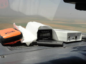 the digital tack checker: it got the black screen of death. I reach up to pull it off the dash and just about burned my arm
with the glare shield - it was quite hot. We cooled it off then built a bonnet from a napkin and reinstalled it on the dash
until it overheated a seond time. We gave up and pulled it off the dash. That is whe the alarms started chiming - TCAD, the
232 input was off line, the altitude alerter was alerting. It was quite a racket. Ellen took the helm while I worked at diagnosing
the problem. I will puling breakers, resetting circuits and switching switches. After the better part of 30 minutes the chimes
stopped but so did a lot of the equipment - we had a massive heat overload. Ellen and I had heard nothing on the radio for
a while and wondered if we still had one. We were now 30 miles out from the flyby and decided to pull out the hand-held just
in case we had radio failure too. We plugged it into the external antenna and got it tuned to the flyby frequency. We did
a radio check on the #1 COM and got a response so we knew we were OK. We made our flyby pass came in to land. I got Vern on
the phone for some real diagnostic help. Seems we simply cooked everything. We left the doors open on the plane and tried
to cool the cockpit. The encoder, we find out, is rated to 138 degrees after which it shuts down. Apparently we reached the
critical temperature in the cockpit. We ran a test after being on the ground for a while and everything was back on line with
no permanent damage. Ellen and I decide to use the tack checker as the canary from now on: if it dies, there is too much heat
and we have to cool down the avionics. the digital tack checker: it got the black screen of death. I reach up to pull it off the dash and just about burned my arm
with the glare shield - it was quite hot. We cooled it off then built a bonnet from a napkin and reinstalled it on the dash
until it overheated a seond time. We gave up and pulled it off the dash. That is whe the alarms started chiming - TCAD, the
232 input was off line, the altitude alerter was alerting. It was quite a racket. Ellen took the helm while I worked at diagnosing
the problem. I will puling breakers, resetting circuits and switching switches. After the better part of 30 minutes the chimes
stopped but so did a lot of the equipment - we had a massive heat overload. Ellen and I had heard nothing on the radio for
a while and wondered if we still had one. We were now 30 miles out from the flyby and decided to pull out the hand-held just
in case we had radio failure too. We plugged it into the external antenna and got it tuned to the flyby frequency. We did
a radio check on the #1 COM and got a response so we knew we were OK. We made our flyby pass came in to land. I got Vern on
the phone for some real diagnostic help. Seems we simply cooked everything. We left the doors open on the plane and tried
to cool the cockpit. The encoder, we find out, is rated to 138 degrees after which it shuts down. Apparently we reached the
critical temperature in the cockpit. We ran a test after being on the ground for a while and everything was back on line with
no permanent damage. Ellen and I decide to use the tack checker as the canary from now on: if it dies, there is too much heat
and we have to cool down the avionics. Our strategy for the ay was to make it to Watertown and we knew we had to make the flyby pass NO LATER than 1800 at Goodland
to be there before 2100. We cut our de-bugging short and launched out for leg 4, passing the timing line with 3 minutes to
spare. Now that we are heading north and the heat of the day has passed, the avionics were no longer in danger of overheating.
We settled in for a nice leg and knew we were making another blind approach into David City. During the leg we say beautiful
green grass for the first time in many days and were quite tickled. Otherwise, leg 4 was pretty unremarkable except for the
haze. We knew we were out of the CAVU territory and strained to see a racer that we were passing 3 miles off in the distance.
A white airplane disappears in haze. Our flyby was over a grass strip that was lush, green, wide and very hard to spot. We
came in blind following the GPS, make the final turn and were scooped up by a massive tailwind. I can tell you that our ground
speed swelled but the rough ride made it difficult to do anything except to hang on and fly the plane. As we crossed the timing
line we hit some bone jarring jolt and everything in the cockpit went flying - the race book broke open, the snack sacks were
in the air and Ellen and I felt the jolt. We were already sinched in pretty tightly from the run into Goodland so now worries
for us. We turned on course and saw our climbout speed settle in at 170 kts. Sweet! Our strategy for the ay was to make it to Watertown and we knew we had to make the flyby pass NO LATER than 1800 at Goodland
to be there before 2100. We cut our de-bugging short and launched out for leg 4, passing the timing line with 3 minutes to
spare. Now that we are heading north and the heat of the day has passed, the avionics were no longer in danger of overheating.
We settled in for a nice leg and knew we were making another blind approach into David City. During the leg we say beautiful
green grass for the first time in many days and were quite tickled. Otherwise, leg 4 was pretty unremarkable except for the
haze. We knew we were out of the CAVU territory and strained to see a racer that we were passing 3 miles off in the distance.
A white airplane disappears in haze. Our flyby was over a grass strip that was lush, green, wide and very hard to spot. We
came in blind following the GPS, make the final turn and were scooped up by a massive tailwind. I can tell you that our ground
speed swelled but the rough ride made it difficult to do anything except to hang on and fly the plane. As we crossed the timing
line we hit some bone jarring jolt and everything in the cockpit went flying - the race book broke open, the snack sacks were
in the air and Ellen and I felt the jolt. We were already sinched in pretty tightly from the run into Goodland so now worries
for us. We turned on course and saw our climbout speed settle in at 170 kts. Sweet!Leg 5 went fast. It was a short leg with great ground speed and the time was ticking. We had 1:45 to get there and our trip time was slate at 1:32 with no hitches and assuming the wind stayed up. It was a gamble but we thought this was going to be the best time to make this leg. Time will tell if we were right or not but for now we have to get there or face the big DQ. We know why this is "Watertown": an area filled with lakes and beautiful wateways. My notes for the approach say that the runways point to 2 lakes. Seeing the area I now realize that this note was not particularly helpful as the whole ares is filled with lakes. Well, it is a straight in approach anyway so there is no turn and no problem. We are watching the time and now th weather. This was the other issue for us. The front line is right over Watertown and looks like it pushed off. But now we see cells popping up to the west and they are moving in our direction. We pass the first cell, the second cell ad the third on is approaching as we are  into Watertown - a lovely roll cloud is heading for the airport. We set up and whiz past the timing line and look at the
clock 2038. We made it - ow to land. There is no time to circle the airport so we do a long downwind for 12 and stare at the
monster of a cloud heading right for us. We get on the ground and quickly work to secure Wild Mama. As we clean
out the plane we see the lovely yellow roses, wiled an near dead - apparently they are only rated to 138 degrees too! No sooner
do we get in the truck to go to the hotel when the rains come - not a minute to spare - but mission accomplished. Now we rest
after a long day. Let's see what tomorrow brings. into Watertown - a lovely roll cloud is heading for the airport. We set up and whiz past the timing line and look at the
clock 2038. We made it - ow to land. There is no time to circle the airport so we do a long downwind for 12 and stare at the
monster of a cloud heading right for us. We get on the ground and quickly work to secure Wild Mama. As we clean
out the plane we see the lovely yellow roses, wiled an near dead - apparently they are only rated to 138 degrees too! No sooner
do we get in the truck to go to the hotel when the rains come - not a minute to spare - but mission accomplished. Now we rest
after a long day. Let's see what tomorrow brings.June 20th - Race Day 2: The Airport Manager who
dropped us at the Casino/Hotel last night came to fetch me, as agreed at 0530 this morning. The only problem was that I did
not wake up until 0535 which is very uncharacteristic of me. I cracked open my eyes, looked at the clock, jumped out of bed
and was dressed and downstairs by 0540. Ellen was still asleep. We were apparently more tired from yesterday than I had thought.
As I walked outside, I noticed the cold and rain that had persisted throughout the night, duping over 3" of rain on the
area and ushering in the cold weather. It was not quite 60 degrees and here I am, once again, in my characteristic "race
uniform" - shorts and a Wild Mama shirt. Brrr. I was heading to the plane to clean her up, check the oil,
fuel, etc. and prepare her for the next leg. We were not in a hurry as the forecast was not good for this morning but
 we thought by the end of the day we may be able to go. we thought by the end of the day we may be able to go.I sat, inside or in the plane, at the airport for the better part of 2 hours watching as the 26 kt wind pushed Wild Mama and the Cirrus, both straining against the tie down ropes. The rain was blowing nearly sideways at this point and I finally rented a car and headed back to the hotel to catch up with Ellen. After we both managed to clean and check the plane with no more than the strong whipping wind, we decided that a tour of the town was in order ad headed in the downtown direction. The first thing that struck us was that the economy in Watertown seems significantly better than in South Florida: there were not the myriad buildings that were sporting "For Rent" signs; cars were in the parking lots and folks were most certainly open for business. The Historic District was even jammed with cars parallel parked along the streets and folks wandering up and down the sidewalks. The street light hosted planters with Posies adding color to the otherwise grey backdrop. The Visitor Bureau inside the Terry Redlin Museum was completely unaware that there was an air race coming to town. This surprised us a bit as the town is not that large. When we arrived yesterday, there was only the airport manager and another gentleman at the FBO. No crowds, no festivities and nothing like the greeting we got in Hereford and Goodland. But it was Day 1 of the race; it was the 5th stop and I imagine that no one expected any racers to arrive even though we filed a flight plan to say we were coming. It was just a long 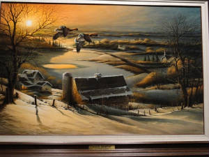 way to get there. But we talked about the race and went on to walk though the Museum filled with over 150 original Terry Redlin
paintings and some of his sketches and other stuff. One painting entitled "Delayed Departure" caught our attentionn
for obvious reasons. There was an ice cream museum housed inside the building along with the usual assortment of gifts. way to get there. But we talked about the race and went on to walk though the Museum filled with over 150 original Terry Redlin
paintings and some of his sketches and other stuff. One painting entitled "Delayed Departure" caught our attentionn
for obvious reasons. There was an ice cream museum housed inside the building along with the usual assortment of gifts.
We stopped for a nice lunch in town and headed back to the airport to check on Wild Mama. It was 1500 and no racers had arrived. The south wind that blew us in was now more northerly; the rains and low ceilings persisted and we called it a day - grounded by the weather. We are back at the hotel this evening to re-group, rest and plan for another long day tomorrow. Batavia: here we come!!!! June 21st - Race Day 3: Things were not as they
seemed today. We were up and ready to go early, at the airport by 0600 to ready Wild Mama for her flight today.
We wanted to depart early but the ceilings between ATY and ASX were ever changing and variable. There were high ceilings,
low ceilings, clear skies; all moving back and forth to make flight
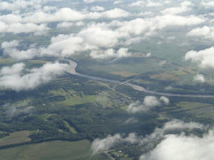 planning very challenging. Once we launched, we expected to have an area of fog in between over which we would fly. It appeared
on schedule; but that is the last thing that happened on schedule. The line of low ceilings persisted for quite a period of
time; then the ceiling came up but, again, was covering a much larger area. Fortunately, there were large gaps in the clouds
that we called "slot canyons" that made for an easy descent back toward the ground. planning very challenging. Once we launched, we expected to have an area of fog in between over which we would fly. It appeared
on schedule; but that is the last thing that happened on schedule. The line of low ceilings persisted for quite a period of
time; then the ceiling came up but, again, was covering a much larger area. Fortunately, there were large gaps in the clouds
that we called "slot canyons" that made for an easy descent back toward the ground.We put Wild Mama in a steep dive to duck down through the canyon and leveled off in anticipation of our flyby into Ashland. We spotted this airport with relative ease, as compared to some of the others which had been most difficult to spot. we executed the flyby and settled in. Classic Racer 3 was already there, having snuck over last night. For now, however, we had the airport to ourselves and thoroughly enjoyed the hospitality of the fine folks at Ashland. We were promptly fueled and had had hot brauts, fresh strawberries and homemade cookies waiting or us. All we really wanted to do is check the weather 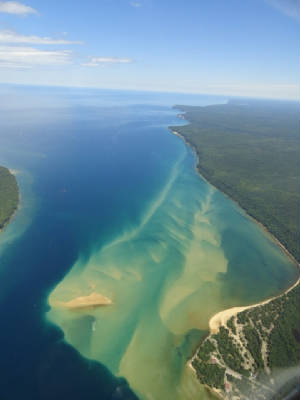 and take care of the plane. But once business was done, Ellen enjoyed the brauts and I dove in to the fruit. We sat off to
the side to relax and work on the flight planning again. The weather was as variable this leg as it was the last: high ceilings,
low ceilings, etc. It was like trying to hit a moving target. We agonized over when to launch; partly because of the weather
and partly because of the commercial airline service schedule which seemed to be another moving target - at least all
of the information we received was inconsistent. and take care of the plane. But once business was done, Ellen enjoyed the brauts and I dove in to the fruit. We sat off to
the side to relax and work on the flight planning again. The weather was as variable this leg as it was the last: high ceilings,
low ceilings, etc. It was like trying to hit a moving target. We agonized over when to launch; partly because of the weather
and partly because of the commercial airline service schedule which seemed to be another moving target - at least all
of the information we received was inconsistent.With heads big, we launched and and just decided to "wing it". We climbed out to some of the most spectacular scenery that we have seen in the green department (as opposed to the spectacular rock formations of the west). There were lush green meadows intertwined with lakes and small streams all sitting in the shadow of Lake superior. This was my first trip to this area and we were happy to be able to see it. Our path took us along 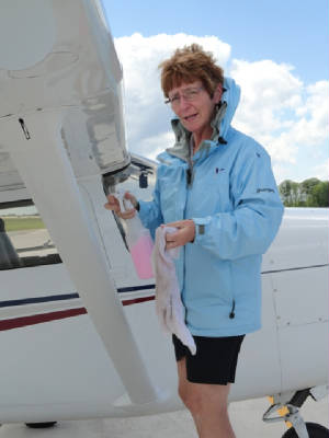 the lake shore for a part of the way. Sections of the Lake were deceptive - blue/green waters that looked so inviting
surrounding vivid green islands. A sand bar rippled out from the shoreline reminding me of the Bahamas. But the danger of
the icy cold waters of the Lake is something that we do not worry about in the tropical Bahamas. We were pleased with the
leg and the scenery but all good things come to an end and it was time to set up for the flyby. We came in behind Classics
24 and 12. We secured Wild Mama and made the call to spend the night here. I was pleased as I had hoped to
stay, being completely new to this area. the lake shore for a part of the way. Sections of the Lake were deceptive - blue/green waters that looked so inviting
surrounding vivid green islands. A sand bar rippled out from the shoreline reminding me of the Bahamas. But the danger of
the icy cold waters of the Lake is something that we do not worry about in the tropical Bahamas. We were pleased with the
leg and the scenery but all good things come to an end and it was time to set up for the flyby. We came in behind Classics
24 and 12. We secured Wild Mama and made the call to spend the night here. I was pleased as I had hoped to
stay, being completely new to this area.We rented a car since town and the hotels were more than 20 miles away from the airport. The Carastros joined us for dinner in downtown Sault Ste  Marie. We ate our fill, got some ice cream and wandered about the town looking at the Soo Lock and stopping the Visitors Center
to read about the history of the Lock. This is our last night out. One more day, 2 more legs, 3 more hours to fly heading
for the finish line. Stay tuned! Marie. We ate our fill, got some ice cream and wandered about the town looking at the Soo Lock and stopping the Visitors Center
to read about the history of the Lock. This is our last night out. One more day, 2 more legs, 3 more hours to fly heading
for the finish line. Stay tuned!June 22nd - Race Day 4:
It was a very early day today. Out hotel in Sault Ste Marie was over 20 miles from the Airport and we need to be there and
be ready for departure at 0630. This meat that we had to leave the hotel at 0530 and .... well, you can do the math for wake
up time from there. Upon arrival at the airport all the planes were lined up and ready to go. There were 34 racers who overnighted
there and all were poised and ready to fly. We were #6 on the list to depart but we help back because of some reported low
ceilings near Benton Harbor and we wanted to make sure all was cleared out first. We launched about 0730. This leg, like the last in the upper peninsula of Michigan
was beautiful. We flew more or less along the shoreline of Lake Michigan, passing Mackinac Island and some other interested
and picturesque places along the way. The air was still and smooth for a change. It was a great way to start the last day
of the race, especially after some of the bone jarring rides of the days before. The winds were not as spectacular as they
had been coming out of Hereford but we were still on the plus side so we were pleased. In a short time we arrived at Benton
Harbor for the flyby. It was like a pit crew coming to greet us. We were promptly fueled and ready to go but the low ceilings
were now persisting on this leg so we waited it out for a while staring at the weather trying to will it into submission.
Once the ceilings lifted and we felt comfortable enough we made the final dash for home. We climbed out in the still air again only to encounter a cloud bank that
forced us back down to the lower levels. We made the remained of the ride at a less than desirable altitude but the short
distance of the leg made it impractical for us to climb again. In short order we had arrived at Batavia and made the final
fly by pass. It is all over now. Ellen ad I had a great time and we were pleased with our performance, although we knew there
were some challenges where we could have done better. We have a year to reflect on those challenges, but for now we are happy.We
met other racers coming in all smiles and we heard tales of the racers who put down in Luce County because Sault Ste Marie
went IFR after they launched. We herd other tales of mechanical issues and overcoming them and we were saddened that Classic
Racer 34 had a prop leak and was forced out of the racer after the second leg. All other racers, however, made it in to the
finish with minutes to spare. It was a great evening and we all celebrated our accomplishment at the melt down gathering at
the hotel in Batavia. Now we wait. We wait for "the call" that we all hope comes to tell us to be ready for inspection
the next morning. At 2330 my cell phone rang. I immediately got excited, heart racing. But it was one of the judges saying that there was a "penalty note" on our Goodland fly by that we made a right turn out after the fly by. I briefly reviewed the fly by procedure and determined that the proper procedure was a straight out departure and told the judge for the life of me I cannot imagine why I would make a right turn instead of going straight. I expressed my objection and she said to gather my proof and to come see them in the morning. I flew with the tracker this year so I went back to the tracker file and pulled the tracker record, making a .pdf copy of the flyby. Straight as an arrow: the tracker showed the straight out departure. Although I was quite shaken by this news ... and disappointed that we have received no other phone calls, I will take this proof to the judges in the morning. It is nice to have the panel of judges who are fair and open minded, giving the racers an opportunity to present our "arguments" and I am confident that the outcome will be favorable although I can also tell you that it is still worrisome. This is the first judge call Team Wild Mama has received in 6 years and I hope it will be the last. 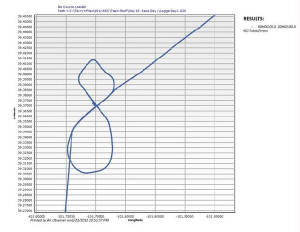 June 23rd
- "The Call": Actually, there were several this morning. The tracker file sent to the judges resolved
the Judge Call issue. You can see clearly there is a proper fly by in and out of Goodland. The must have confused Classic
11 with another racer crossing near the same time. Then it happened: at 0900 this morning "The Call" - the real
"Call" came in. We are running off to be inspected meaning we finished somewhere in or near the top 15. Stay tuned!
It has comtinued to be a whirlwind of a day. We were out at the airport for several hours for the aircrat inspection then ran back to the hotel to meet with the Chief Scorer to review our numbers and final score. We were very close being off by only a few seconds on several of the legs. We were heading over to the Sporty's Birthday Bash when I got a call from the chief Aircraft Inspector that there was a problem with Wild Mama's log books. I knew better but, apparently, what happened is that they could not find all of the required entries in the volumes of paper so we were assessed a 2 kt penalty unless we could locate and tab all of the required entries in the books. Vern sprung into action. I got the log books, Ellen raced to the Office Depot for some tabs and Vern started hunting. We were required to file a Protest of the inspection results to have any chance of having the penalty reversed. After the better part of 2 hours all of the items were located, identified, tabbed and signed off by the ARC inspectors but we have to wait until tomorrow for a judge sign off and ruling on our Protest. So as it sits now, we have a 2 kt penalty. I am confident of the outcome, but here comes another restless night! June 24th - Awards Banquet: We got the call this
afternoon that the penalty was removed by the time we got back from all of the last de-briefings and ARC board meeting. It
has been a long day made longer by the knot in my stomach wondering if we really made the Top 10. This is the 4th inspection
call with a 1st, 11th and 14th place finish in the past. It is difficult to not get your hopes up and remain calm while waiting
for the news so I have busied myself with the preparation of the Awards Banquet Program. It is time to head off |
 his way with Wild Mama in preparation for the race. There has been some concern about the high amount of oil consumption
and that strange metal in the oil filter so he sent the oil and the filter off for analysis. It came back with aluminum (which
he suspected to be the only aluminum piston pin plug in the engine) and a lot of "grit" (attributable to "blow
by"). With the engine at TBO but a few more trips to put on her before the new engine change-out, something had to be
done. It just makes me nervous being so close to the race having anything done. Immediately upon my arrival, he
his way with Wild Mama in preparation for the race. There has been some concern about the high amount of oil consumption
and that strange metal in the oil filter so he sent the oil and the filter off for analysis. It came back with aluminum (which
he suspected to be the only aluminum piston pin plug in the engine) and a lot of "grit" (attributable to "blow
by"). With the engine at TBO but a few more trips to put on her before the new engine change-out, something had to be
done. It just makes me nervous being so close to the race having anything done. Immediately upon my arrival, he  started by draining the oil and I left her in his capable hands for the evening.
 determine that leaning has been done appropriately and there was nothing excess or burned in the system. All of this was
good news. Now, I just have to wait for him to complete the job and get her back to do the "break in flying" before
Ellen and I leave for the race. Time is ticking!
determine that leaning has been done appropriately and there was nothing excess or burned in the system. All of this was
good news. Now, I just have to wait for him to complete the job and get her back to do the "break in flying" before
Ellen and I leave for the race. Time is ticking!
 handicap run for Classic 23. The air was calm and still and although there were storms south in the Miami area, Palm Beach
and Lantanna were sitting pretty. We met Susan at 0700 and got to work. Susan grabbed all of her "race approved"
materials for the plane and cleaned out everything else that was not "approved" for the handicap flight. We jumped
on the scale to make compensation for weight differentials from co-
handicap run for Classic 23. The air was calm and still and although there were storms south in the Miami area, Palm Beach
and Lantanna were sitting pretty. We met Susan at 0700 and got to work. Susan grabbed all of her "race approved"
materials for the plane and cleaned out everything else that was not "approved" for the handicap flight. We jumped
on the scale to make compensation for weight differentials from co-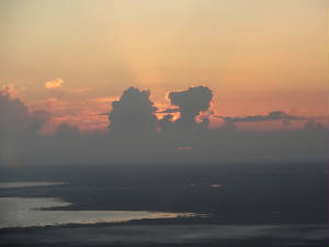 pilot to check pilot and blasted off toward Lake Okechobee. After a quick climb-out we set the auto-pilot, leveled off and
... sat there watching the time go by. With each leg at approximately 6 minutes, we accomplished the handicapping task in
nothing flat and made our way back to Lantanna. We signed off on all the paperwork and transmitted the tracker information
to ARC handicap officials who declared the run a success!
pilot to check pilot and blasted off toward Lake Okechobee. After a quick climb-out we set the auto-pilot, leveled off and
... sat there watching the time go by. With each leg at approximately 6 minutes, we accomplished the handicapping task in
nothing flat and made our way back to Lantanna. We signed off on all the paperwork and transmitted the tracker information
to ARC handicap officials who declared the run a success!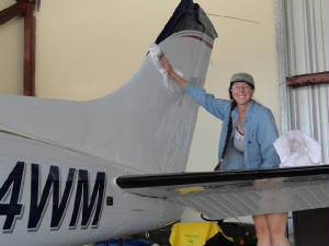 everything buttoned up to see how the temperatures and oil consumption would be. Everything was perfect. I was not concerned
with weight or "approved or not approved" materials: I was looking for the engine performance to
everything buttoned up to see how the temperatures and oil consumption would be. Everything was perfect. I was not concerned
with weight or "approved or not approved" materials: I was looking for the engine performance to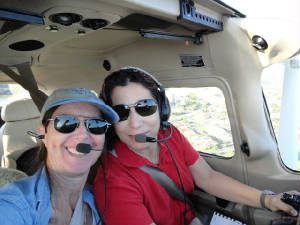 have stabilized after the work that was done. Vern and I checked the temperatures and oil ad we declared the mission a success.
Friday, the detailers come to swat the bugs off.
have stabilized after the work that was done. Vern and I checked the temperatures and oil ad we declared the mission a success.
Friday, the detailers come to swat the bugs off.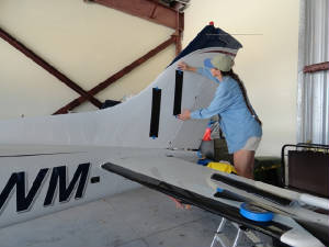 straight edge; 4 swipes with the exacto knife and I have numbers. I taped them up to get a good look-see to be sure
 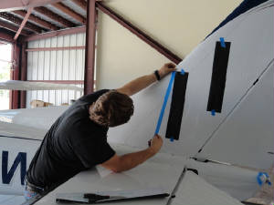 they were high enough, that nothing was blocking them and that there were no stripes interfering with the numbers. This is
partially why we selected this paint scheme - so the race number placement would be easier and cleaner. After I got the first
side taped into position Vern came to inspect.... needless to say, he finished the job when he saw that my placement was crooked
again. He was mortified (he tells me now) seeing the pictures in the newspaper with crooked race numbers. He will NOT have any
more of that! Oops!
they were high enough, that nothing was blocking them and that there were no stripes interfering with the numbers. This is
partially why we selected this paint scheme - so the race number placement would be easier and cleaner. After I got the first
side taped into position Vern came to inspect.... needless to say, he finished the job when he saw that my placement was crooked
again. He was mortified (he tells me now) seeing the pictures in the newspaper with crooked race numbers. He will NOT have any
more of that! Oops! 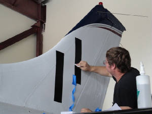
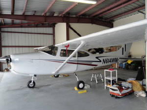 "Sunday Sedan" to the "Lean, Mean Racing Machine"! Wild Mama's handicap flight is scheduled for
Saturday, weather permitting. We just wanna fly now.
"Sunday Sedan" to the "Lean, Mean Racing Machine"! Wild Mama's handicap flight is scheduled for
Saturday, weather permitting. We just wanna fly now.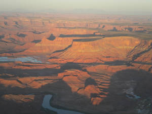 first light which occurs here about 0550. Up at 0400, we packed, grabbed some coffee and breakfast and headed off to
the airport about 15 miles away. Arrangements had already been made for our early departure with a late evening fueling, and
drop boxes for the hotel and car keys. All went according to plan and we Wild Mama lifted off just as the sun peeked over
the horizon.
first light which occurs here about 0550. Up at 0400, we packed, grabbed some coffee and breakfast and headed off to
the airport about 15 miles away. Arrangements had already been made for our early departure with a late evening fueling, and
drop boxes for the hotel and car keys. All went according to plan and we Wild Mama lifted off just as the sun peeked over
the horizon.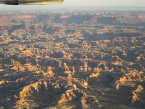
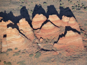 North area contains The Wave but the south area (where we DID secure a hiking permit) has many other Wave-like features which
will have to satisfy our appetite for swirly rocks.
North area contains The Wave but the south area (where we DID secure a hiking permit) has many other Wave-like features which
will have to satisfy our appetite for swirly rocks.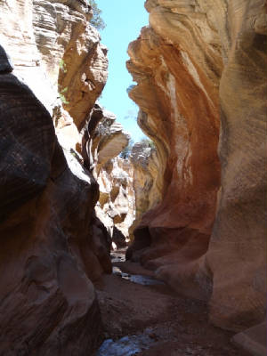 where a pick-up truck veered off the road (back in the 50’s) and became lodged in the Gorge where to one could extract
the truck. Over the years, dirt and sand were applied to make the bridge that we drove across today. Believe me, it was NOT
a standard DOT issue bridge and, again, we were happy to have the 4x4. Shortly thereafter we arrived at Willis Creek Slot
Canyon and prepared for our hike.
where a pick-up truck veered off the road (back in the 50’s) and became lodged in the Gorge where to one could extract
the truck. Over the years, dirt and sand were applied to make the bridge that we drove across today. Believe me, it was NOT
a standard DOT issue bridge and, again, we were happy to have the 4x4. Shortly thereafter we arrived at Willis Creek Slot
Canyon and prepared for our hike.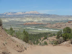 service. The view from the other direction looked strange and we could not recognize some of the landmarks we had seen on
the way in. Fortunately, the creek provided all the direction we needed and we made it back to the trailhead and the car in
short order.
service. The view from the other direction looked strange and we could not recognize some of the landmarks we had seen on
the way in. Fortunately, the creek provided all the direction we needed and we made it back to the trailhead and the car in
short order.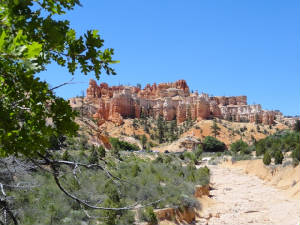 into view: it was a sea of tri-colored hoodoos standing tall overlooking the plateau and calling our names to stop at the
next scenic view area.
into view: it was a sea of tri-colored hoodoos standing tall overlooking the plateau and calling our names to stop at the
next scenic view area. 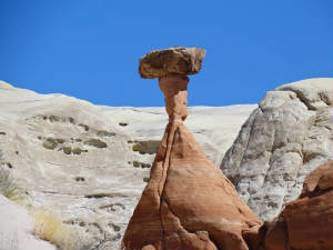 Escalante Visitors Center to see what we wanted to do. Since we got in so early, we had a whole extra day to play with. We
made it to the Center with 5 minutes to spare until the last lottery for the Wave for a hike tomorrow. The final 10 slots
were up for grabs and there was a room full of hikers, including us, who put their names in for the slots. Unfortunately,
luck was not with us for the Wave and our last opportunity to hike the Wave was gone.
Escalante Visitors Center to see what we wanted to do. Since we got in so early, we had a whole extra day to play with. We
made it to the Center with 5 minutes to spare until the last lottery for the Wave for a hike tomorrow. The final 10 slots
were up for grabs and there was a room full of hikers, including us, who put their names in for the slots. Unfortunately,
luck was not with us for the Wave and our last opportunity to hike the Wave was gone.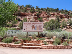 and 30,000 leased acres from the BLM. There is a horse house; dog house, cat house, bird house, bunny bungalow, pig, goat
and sheep house and they take all unwanted and homeless animals to live out their lives there if they cannot be adopted. We
toured the facility and got to spend some quality kitty time with some of the residents. Also wandering bout the property
are all of the wild animals that regularly inhabit the area including the wild turkey and coyote that we saw. We walked through
Angel’s Rest, the pet
and 30,000 leased acres from the BLM. There is a horse house; dog house, cat house, bird house, bunny bungalow, pig, goat
and sheep house and they take all unwanted and homeless animals to live out their lives there if they cannot be adopted. We
toured the facility and got to spend some quality kitty time with some of the residents. Also wandering bout the property
are all of the wild animals that regularly inhabit the area including the wild turkey and coyote that we saw. We walked through
Angel’s Rest, the pet  cemetery and listened to the tranquil sounds of the wind chime trees, purchased in dedication to lost pets. It was an amazing
facility.
cemetery and listened to the tranquil sounds of the wind chime trees, purchased in dedication to lost pets. It was an amazing
facility. day tomorrow in Bryce Canyon.
 We descended along a gentle slope among the hoodoos and pine forest wondering how we were ever going to get to the bottom.
Every turn was another opportunity for a view more exciting than the last. The hike was billed as a 2-3 hour loop. By the
time 40 minutes passed we were beginning to wonder about the trip back up to the rim of the canyon. Departing the Queens Loop,
we veered off to the Navajo Loop which was more along the lower canyon level and through a lush forest of pines. The day started
cool and with the winds lingering from yesterday, it was not a bad hike at all, but a bit cool for my taste. It seems that
while I was busy checking the weather for our anticipated Tuesday morning flight to Sedona, Ellen was wisely checking then
forecast for today. I should have known something was up when Ellen emerged in long pants and a long sleeve shirt and I was
still in shorts and a tank top. It seems we had a failure to communicate. But I digress ...
We descended along a gentle slope among the hoodoos and pine forest wondering how we were ever going to get to the bottom.
Every turn was another opportunity for a view more exciting than the last. The hike was billed as a 2-3 hour loop. By the
time 40 minutes passed we were beginning to wonder about the trip back up to the rim of the canyon. Departing the Queens Loop,
we veered off to the Navajo Loop which was more along the lower canyon level and through a lush forest of pines. The day started
cool and with the winds lingering from yesterday, it was not a bad hike at all, but a bit cool for my taste. It seems that
while I was busy checking the weather for our anticipated Tuesday morning flight to Sedona, Ellen was wisely checking then
forecast for today. I should have known something was up when Ellen emerged in long pants and a long sleeve shirt and I was
still in shorts and a tank top. It seems we had a failure to communicate. But I digress ...
 mesmerized by the sight, the feeling of being back on top of the world and stared out at the multi-colored canyon walls trying
to burn the image in my brain to savor it for a long time to come. This is what I had come to see.
mesmerized by the sight, the feeling of being back on top of the world and stared out at the multi-colored canyon walls trying
to burn the image in my brain to savor it for a long time to come. This is what I had come to see. specimens of flora and fauna.
  to the banquet in a couple of hour to see our fate. Watch or the facebook mobile update as soon as we get any news.
|
|||||||||

|
|||||||||
|
|||||||||


| undefined |
 |
| undefined |

 |
| International Organization of Women Pilots |