|
|
Enter subhead content here June 25th - Piqua, OH: We said "see ya soon"
to our race friends as we watched a sea of planes lift off from Batavia. Wild Mama was loaded with a few small
items then Vern and I grabbed one car; Ed and Ellen grabbed their car and we each headed off in different directions
for the first time in nearly one month. Ellen is headed back to FL with Ed and Vern and I are headed north to Piqua, OH.
Piqua, OH??? What is there? I will tell you: the Hartzell Propellor Plant!
 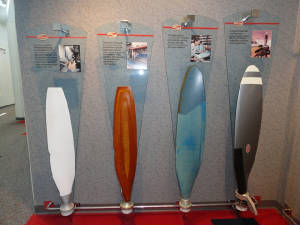 Vern made arrangeents with Mike at the plant for us to get a tour. We headed up to Piqua and met Mike to learn about the manufacturing
process of the Hartzell props. We saw a brief panel by panel explaination of the process of the creation of the composite
prop and for the aluminum blades. He told us about the company history and we started the tour backwards, seeing the shipping
and inventory first then proceeding on. We toured the painting department, prop balancing, primary machining, finish machining,
assembly, quality control .... in essence, everything from the raw casting to the shipping. Everything but the original
casting is done on site. The most interesting thing that I learned was about the process of matching the blades according
to weight and how lead wool is used to make the minor adjustment in Vern made arrangeents with Mike at the plant for us to get a tour. We headed up to Piqua and met Mike to learn about the manufacturing
process of the Hartzell props. We saw a brief panel by panel explaination of the process of the creation of the composite
prop and for the aluminum blades. He told us about the company history and we started the tour backwards, seeing the shipping
and inventory first then proceeding on. We toured the painting department, prop balancing, primary machining, finish machining,
assembly, quality control .... in essence, everything from the raw casting to the shipping. Everything but the original
casting is done on site. The most interesting thing that I learned was about the process of matching the blades according
to weight and how lead wool is used to make the minor adjustment in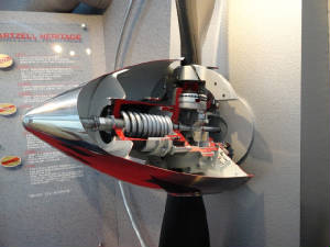 weight differential. Fascinating. weight differential. Fascinating.We thanked Mike then headed over to Dayton for the big event tomorrow: a trip through the Wright Patterson Air Force Museum. June 26th - National Museum of the US Air Force: A lifelong
dream for Vern and high on my "gotta do" list, we visited part of the National Museum of the US Air Force in
Dayton today. We started with the Presidential and R & D hangard, followed by the early aviation and WWI exhibit, the
Holocost exhibit, WWII, Korea and Southeast Asia exhibits with a break to watch the iMax "Air Racers" presentation.
National Museum of the US Air Force - Volume 1 National Museum of the US Air Force - Volume 2 June 27- July 1 - Cabin, Sweet Cabin: It is always a
pleasure to come back "home"; and Spencer, TN is certainly one of those places for me. We spend all too
 little time at the cabins here, enjoying the peace and serenity and the fantastic folks who we call our friends. We arrived little time at the cabins here, enjoying the peace and serenity and the fantastic folks who we call our friends. We arrived
 Wednesday after the short, but scenic, flight from Cincinnati and will remain here through the weekend working on the
cabin, visiting friends and taking a much needed break. Sunday, Vern hops on a commercial flight from Knoxville back to home
(Uncle Vern is coming, Stubby .... hang on) and I will head to Maryland to spend some time with my Mother and other family
before heading north. The adventure continues ... Wednesday after the short, but scenic, flight from Cincinnati and will remain here through the weekend working on the
cabin, visiting friends and taking a much needed break. Sunday, Vern hops on a commercial flight from Knoxville back to home
(Uncle Vern is coming, Stubby .... hang on) and I will head to Maryland to spend some time with my Mother and other family
before heading north. The adventure continues ...July 1 - "Smokin'": More like "Smokies"
as in the Great Smokey Mountains... Heading out of Tennessee and toward Knoxville to drop off Vern so he can catch a commercial
flight home today. The Allegiant Flight was only $68 to Punta Gorda - I cannot get him to the Tennessee border for $68 in
Wild Mama! The haze today was the worst that I have seen for a while. We climbed to 5500' hoping for a little break
but it was thick and the Mountains were not visible until we were right on top of KTYS ...... in fact, the airport was not
visible until we were less than 10 miles out so that tells you the state of the fog.
With Vern safely delivered to the airport, I turned Wild Mama north for Maryland to spend a few days with my sister and visit Mother who is now in a nursing home. The Smokies continued to live up to their name. The forward visibility was maybe 10 miles but greatly obscured. I decided to file so I could have a little help on 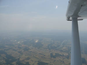 spotting traffic but also for getting in to Westminster as P40 was expanded and the corridor was narrow. I filed for 5000'
but was assigned 7000' for terrain. I had thought 5000' was sufficient but when I saw how I was vectored out from Knoxville,
I understood the terrain issue. So, east out over the mountains I go, missing the clear and 100 mile visibility from the west.
I settled in to stare at the gauges as that was all I could really see. spotting traffic but also for getting in to Westminster as P40 was expanded and the corridor was narrow. I filed for 5000'
but was assigned 7000' for terrain. I had thought 5000' was sufficient but when I saw how I was vectored out from Knoxville,
I understood the terrain issue. So, east out over the mountains I go, missing the clear and 100 mile visibility from the west.
I settled in to stare at the gauges as that was all I could really see.Reaching Tri-Cities, I was given an early hand-off and had great difficulty in raising ATC. I turned up the squelch so I could barely make out the words of the controller. He switched me to another frequency that was better but still not good. I tried radio #2 which was a little better but still not good but just accepted it for a while until I was more in range. The next hand-off to Indy Center was no better and I was suffering from the same issue although radio #2 reception was significantly better than #1. I kept both radios on, transmitting on #1, listening on #2. He gave me a changeover frequency and I readied the back-up radio, just in case there was something more 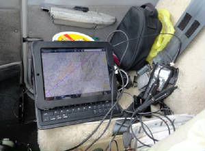 sinister going on than atmospheric disturbances. By the time I changed to Washington Center all was well. sinister going on than atmospheric disturbances. By the time I changed to Washington Center all was well.I had enjoyed a nice little tailwind the whole way, making handicap speed or slightly better. If we were racing, I would have been disappointed with the +2 but cruising along at 160+ kts for grins and giggles was OK by me. About 100 miles out of Martinburg, WV, I could feel Wild Mama's tail lift up and knew I hit a good updraft and watched as the ground speed zipped up past the 170 kt mark. Sweet! I was following the mountain chain and there was not any discernible ridge-line but a series of crests over the course that I was following. I could see no apparent reason for the sudden up-draft was was not going to complain. As quickly as we receive, however, we have to give: Wild Mama's nose pitches up and I watch as the ground speed diminishes - 150, 140, 130, 120 .... Yikes! The airspeed dropped to 100 kts as the downdraft was making it hard to hold altitude. I watched closely to make sure that it dropped no more, lest I have to dive to regain some speed. Finally levelling off, she held steady, the shot back up to over 170 kts of ground speed again - this one is a roller coaster that I will ride for about 20 minutes until I start my descent over Martinburg. Passing Frederick and the expanded P40, I cancel my IFR flight and make the final descent into Carrol County VFR in the persistent haze and brisk cross winds. I was glad to be here. The next week will be here enjoying the family and making taking a little side trip with my sister before continuing the trek northward. July 5th - Luray Caverns:With my niece celebrating her
16th birthday in August, it was time to take her on a little airplane adventure so we selected Luray Caverns - partly because
caves are cool (both literally and figuratively) and because she had never been to a cave before and because the reviews of
the Luray Airport on
 Airnav were nothing short of outstaning. Since we had a spare seat in the plane we invited Faye, my friend, Hal's sister
who, we found out graduated in the same class as Michelle. They were homeroom mates and knew of each other but never really
knew each other during school. Small world. Airnav were nothing short of outstaning. Since we had a spare seat in the plane we invited Faye, my friend, Hal's sister
who, we found out graduated in the same class as Michelle. They were homeroom mates and knew of each other but never really
knew each other during school. Small world.With a full plane and perfect, albeit hazy weather, we blasted off at 0800 into the cool skies, climbing out to 4500' to avoid the 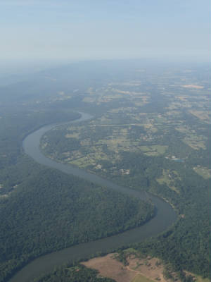 airspace, heat and bumps from the low lying hills surrounding the area. Faye had not been in a small plane for a long time
and this was Ashley's second ride; sister, Michelle is an old pro by now having flown many adventures with me. It was a shame
there was so much haze for a sight seeing tour: the mountains were lush and green with the geometric patters of the farm fields
beckoning us to photograph them. But to colors just seemed to wash out and did not stand out against the smoky gray. The flight
was smooth until we descended into Luray, an airport tucked up against the mountains side in the Luray Valley. There was a
NOTAM for a fire nearby and the fire fighting helicopters were operating out of Luray but we got in in between fire flights
without incident. airspace, heat and bumps from the low lying hills surrounding the area. Faye had not been in a small plane for a long time
and this was Ashley's second ride; sister, Michelle is an old pro by now having flown many adventures with me. It was a shame
there was so much haze for a sight seeing tour: the mountains were lush and green with the geometric patters of the farm fields
beckoning us to photograph them. But to colors just seemed to wash out and did not stand out against the smoky gray. The flight
was smooth until we descended into Luray, an airport tucked up against the mountains side in the Luray Valley. There was a
NOTAM for a fire nearby and the fire fighting helicopters were operating out of Luray but we got in in between fire flights
without incident.We were immediately met by Kenny who tied us down, got our fuel order and offered to drive us to the Caverns and Museums. In no time were were heading down 164' underground into Luray Caverns. I was there as a young child but had no real recollection of 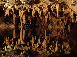 the caves. Michelle remembered the organ and Faye recalled that there were lots of steps. Well, the steps were replaced with
a nice ramp system and the organ was not playing the same tune as Michelle recalled; but the cave formations, they say, remained
virtually unchanged over these long years. Stalactites (the ones on top) and stalagmites (the bottom ones) grow VERY slowly
so unless one has a really good memory, the formations should pretty much look the same from years past. I enjoyed all of
the cave features from the organ to the "fried eggs", the "fish market" and the other assorted shapes
that one could make out in the rocks. You can have as many opinions for rock formations as we have for guessing what shape
a cloud formation might be. the caves. Michelle remembered the organ and Faye recalled that there were lots of steps. Well, the steps were replaced with
a nice ramp system and the organ was not playing the same tune as Michelle recalled; but the cave formations, they say, remained
virtually unchanged over these long years. Stalactites (the ones on top) and stalagmites (the bottom ones) grow VERY slowly
so unless one has a really good memory, the formations should pretty much look the same from years past. I enjoyed all of
the cave features from the organ to the "fried eggs", the "fish market" and the other assorted shapes
that one could make out in the rocks. You can have as many opinions for rock formations as we have for guessing what shape
a cloud formation might be.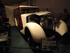 We followed ourcave excursion with lunch and a tour of the antique car/carriage museum and the farm and local history museum.
Both ere deceptively packed with assorted items and both were quite interesting. Kenny fetched us back for the slightly bumpy
trip home in the early afternoon heat. We passed Harpers Ferry and had to make a slight detour to get close enough to see
in the persistent haze. Heading back to Carroll County, the GPS starting squawking "terrain, terrain, pull up pull up"
as we landed; apparently, it did not like the large up-sloping and hill at the end of the runway with an airplane pointing
straight to the ground. I suppose she forgot we were landing! We followed ourcave excursion with lunch and a tour of the antique car/carriage museum and the farm and local history museum.
Both ere deceptively packed with assorted items and both were quite interesting. Kenny fetched us back for the slightly bumpy
trip home in the early afternoon heat. We passed Harpers Ferry and had to make a slight detour to get close enough to see
in the persistent haze. Heading back to Carroll County, the GPS starting squawking "terrain, terrain, pull up pull up"
as we landed; apparently, it did not like the large up-sloping and hill at the end of the runway with an airplane pointing
straight to the ground. I suppose she forgot we were landing!July 9th – Penns Cave to Ticonderoga:
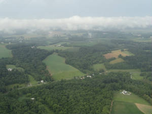
Awakening to the sound of a thunderstorm, I chuckled as this was a flying day and it would seem to be the first day with Looking to the west as I departed, I could see the large fog bank in the near ground –
we were truly JUST on the edge; but my route to Penns Cave Airport was Penn’s Cave was a 2500’ runway with a note in the AFD about a 3.35° upslope on the first 800’ of runway 7, making 7 the preferred landing runway all else being equal; but the winds were decidedly favoring 25. Approaching from the south, I could not see the airport at all until I was practically right on top of it. Unless you plan on making a really tight pattern, you were not going to be doing your downwind leg inside of the valley. The airport in tucked neatly into Penn’s Valley, lodged between 2 small “hills” each about 1200’ about the airport elevation. I flew an extended downwind over the southern hill, and then turned a quick base and 4 mile final giving me plenty of time to lost 1400’ on the final. The approach through the valley was fun and I was able to lose the altitude and slow my speed before touching down. But this airport would be a great photo for “deceptive views” in the Airplane Flying Handbook: it is 2500’ long, 40’ wide and that “800’ up-sloping” thing seemed to more like just over half of the runway rather than 800’. I guess the part that is mentioned is the last 800’ because of the severity of the slope but the remaining part of the slope just seemed to go unmentioned … along with that dip in the first 600’. So immediately upon touching down I was easing on the breaks – not enough to flatten the tires, but certainly with a bit more enthusiasm than normal – an rolled, and rolled and rolled out to the end of the runway parking area in the grass. I chuckled as I looked out to see the upped part of the runway completely disappear and the departure end of 25 drop off before the sharply rising section of farm field. . . note to self: use 20° of flaps on departure and your best short field technique.
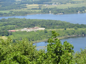
Departing the area I made a long straight out departure while gaining altitude and cleaning up the plane, then sashayed right to get enough space to make the turn in the valley to head north. I was still climbing but did not have quite enough altitude to clear the peaks. Turning on course, I finished my climb to 3500’ and skipped across the hill tops on my way to Ticonderoga. Weather was reporting overcast at 7000’ at Lake George, just southeast of my destination so I stayed under the clouds not wanting to get stuck, but also wanting a view of the greenery below. After so many days seeing brown rocks, the greenery was still a welcomed sight … and the haze had finally dissipated enough that the view was nothing short of spectacular. My
approach into Ticonderoga was over Lake George so I could descent rather than doing a dive bomb to the runway. The lake was
a beautiful blue-green hue filled with boats and sporting a shoreline with homes scattered in and amongst the trees. I made
a straight in approach to runway 2 and was met by Caroline Baldwin and We ended our tour
and headed to the house. My first words were “Wow!”. The house sits on 2 acres on Eagle Lake, right on Eagle Lake
with the main living area June 10th – Ticonderoga: The heat of the summer was
left behind as I awakened to a cool morning at the Lake. I grabbed my morning coffee and watched the sun rise while the loon
serenade continued. The house faces west and the thickly wooded area surrounding the house prevents a full out view of the
morning sun but the colors of the morning reflected off the clouds revealing a red glow that infiltrated the sky for a brief
time before giving way to the brilliant blue sky of the day. A breeze was blowing across the lake and I sat sipping coffee
to the site of shimmering leaves and the chatter of the chipmunks and squirrels, still arguing over those nuts.
July 11th - The Big 50: No: my 50th birthday was last
year and other than the fact that I celebrated it at the conclusion of the 2011 Air Race Classic, it really has nothing to
do with airplanes. This 50 does.
The morning was nothing short of fabulous: cool air (of course that necessitated the early morning fire in the fireplace) and cloudless blue skies. Today was a day that I have been waiting for and working toward for 7 years. I left out of Ticonderoga en route to Rutland, VT. Four to go. The flight was quite short and I was  making my descent to land within minutes after my departure. I landed, taxied back to runway 19, re-set the GPS, checked
the charts to make the climb out over the mountains and powered up. Three to go. making my descent to land within minutes after my departure. I landed, taxied back to runway 19, re-set the GPS, checked
the charts to make the climb out over the mountains and powered up. Three to go. The departure turned out to be my favorite of the day. I had to initially remain in the valley south of the airport before turning on course over the mountains. It is so good to have such a high performance airplane and to be able to use that performance when it counts. We climbed at 1500 fpm and turned toward the mountain. The terrain warnings flashed and the GPS started warning: "Terrain, terrain, pull up, pull up"; but I was already pointing toward the sky and had plenty of time to clear the saddle between the peaks. Up and over, I briefly leveled off before swooping down over the hill side. I was soaring like and eagle and having a blast. 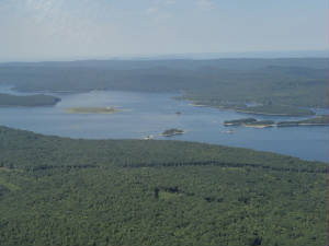 The terrain below was tree-filled and rugged with a smattering of lakes tossed about to break up the expansive forest and
it was such a thrill to be air-borne today. I was heading to Dillant-Hopkins Airport, NH. The traffic picked up with several
planes coming into the pattern landing on runway 2 so I joined them although on this windless day, any runway would work equally
as well. I flew my downwind, base and final, landed and taxied to the end of runway 20 for departure. Two to go. The terrain below was tree-filled and rugged with a smattering of lakes tossed about to break up the expansive forest and
it was such a thrill to be air-borne today. I was heading to Dillant-Hopkins Airport, NH. The traffic picked up with several
planes coming into the pattern landing on runway 2 so I joined them although on this windless day, any runway would work equally
as well. I flew my downwind, base and final, landed and taxied to the end of runway 20 for departure. Two to go.With Wild Mama prepared and charts checked we blased off to the south remaining at eagle level past Quabbin Res and on into Windham, CT. Again, so many pilots were taking advantage of the stellar conditions that I had to go around the patch a bit before landing on runway 27 behind the Cirrus, then preparing to depart behind the Cirrus and the helicopter after setting up for the last 33 nm leg. One to go - coming down the home stretch. This was to be another very short leg giving me barely enough time to "clean up" the plane before I had to "dirty her up" for landing. The traffic at North Central in 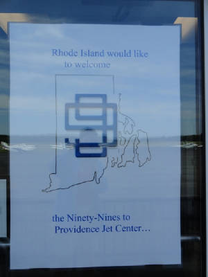 Providence, RI was using runway 5 and they were stacked up waiting to get it. I slowed even more than I had been, still kind-of
loping along, swung out for a wide base leg and blended in with the other traffic. With an uneventful landing on runway
5, I had completed my goal of landing a small aircraft in all 50 states. (Hawaii is a little cheat because we arrived by boat
then took a helicopter ride over the volcano several years back; but I say it still counts.) And what better way to celebrate
than arrive at the annual 99s Conference being held in Providence, RI with 250 of my best pilot friends! Providence, RI was using runway 5 and they were stacked up waiting to get it. I slowed even more than I had been, still kind-of
loping along, swung out for a wide base leg and blended in with the other traffic. With an uneventful landing on runway
5, I had completed my goal of landing a small aircraft in all 50 states. (Hawaii is a little cheat because we arrived by boat
then took a helicopter ride over the volcano several years back; but I say it still counts.) And what better way to celebrate
than arrive at the annual 99s Conference being held in Providence, RI with 250 of my best pilot friends!July 15th - Heading Home: After 42 days, many
hours of flight and thousands of miles, I am finally heading home to Florida. (Hang on Stubby!) I filed IFR from
Providence because of some weather around the New York City area but the first leg was otherwise looking pretty good. Sure
enough, right on schedule the rains
July 16th - Home Sweet Home: Often times flying we made decisions then
wonder if it was the right one or not. Usually if we make the wrong decision, we know because we suffer through the flight
and (hopefully) live to give a "Don't let this happen to you" kind of story. This time, I knew I made the right
decision. One I landed yesterday, I was quite tired and really did not feel like waiting out the storms. I went straight to
the hotel and got a room for the evening, falling asleep quite early and having to awaken myself for a meeting at 2000 hrs.
I promptly fell back asleep and slept soundly through the night. That would have been the first hole in the swiss cheese;
added to "get-home-itis"; worsening storms; a sucker hole behind the first line of storms and ... well, you get
the picture. |
 clouds in a long time. I checked the weather to see that Westminster was on the very northern edge of the massive storm and
that thunder was more distant than I had thought. I finished packing and made my way to the airport, arriving in time to see
a Caravan launch to the SE only to disappear into the clouds before leaving the end of the airport property. Looking to the
north, however, there were a few wispy clouds and very flyable clouds – scattered about 6000’. Perfect.
clouds in a long time. I checked the weather to see that Westminster was on the very northern edge of the massive storm and
that thunder was more distant than I had thought. I finished packing and made my way to the airport, arriving in time to see
a Caravan launch to the SE only to disappear into the clouds before leaving the end of the airport property. Looking to the
north, however, there were a few wispy clouds and very flyable clouds – scattered about 6000’. Perfect.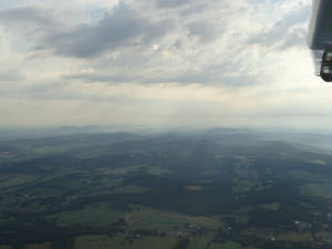 still clear. I climbed out to 2800’; enough to clear all of the rolling hills and sprawling valleys but close enough
to get a close up view of everything. Some areas were relatively overcast with the sun straining to peek through leaving sun
rays that formed an opaque curtain of haze over the landscape. I was hoping for a little bit less haze but the scene was quite
picturesque none-the-less.
still clear. I climbed out to 2800’; enough to clear all of the rolling hills and sprawling valleys but close enough
to get a close up view of everything. Some areas were relatively overcast with the sun straining to peek through leaving sun
rays that formed an opaque curtain of haze over the landscape. I was hoping for a little bit less haze but the scene was quite
picturesque none-the-less. 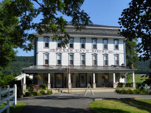 Penn’s Cave is only a short ½ mile walk from the airport so I made my way there and took both the cave tour and
the wildlife tour. This cave is a water cave and the tour is via boat. There are not nearly as many formations as there were
in Luray Caverns but the history and the geology were still quite fascinating. The wildlife tour took us through the 1500
acres of farming area and wildlife preserve seeing various species of deed, elf, black bear, mountain cats and wolf; and ended
(for me) just past the Africa exhibit back at the airport. I skipped the Texas Longhorns and the Mustangs to avoid that short
½ mile walk at high noon.
Penn’s Cave is only a short ½ mile walk from the airport so I made my way there and took both the cave tour and
the wildlife tour. This cave is a water cave and the tour is via boat. There are not nearly as many formations as there were
in Luray Caverns but the history and the geology were still quite fascinating. The wildlife tour took us through the 1500
acres of farming area and wildlife preserve seeing various species of deed, elf, black bear, mountain cats and wolf; and ended
(for me) just past the Africa exhibit back at the airport. I skipped the Texas Longhorns and the Mustangs to avoid that short
½ mile walk at high noon.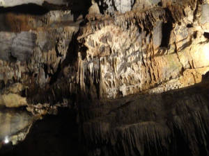
 husband, Bill, to spend a couple of days at their summer retreat on Eagle Lake. We unloaded Wild Mama (did I really have
that much stuff in the plane???) and headed off for the tour of the old town and local area and Mount Defiance. Bill is an
excellent tour guide, obviously having studied the history of the area. He told about the strategic location of the town along
the waterway, being at a narrow point in the River. He pointed out that one can travel by water from New York City up through
the river and lake to get into Canada, and then continue on back out to the Atlantic Ocean. He pointed out the old location
of the paper mill and we stopped in the Visitor’s Center where I got a box of pencils (remembers those old pencils we
had as kids that said Dixon/Ticonderoga #2?). We continued up atop Mount Defiance where you could see the Fort and an expansive
view of the River that divides New York and Vermont.
husband, Bill, to spend a couple of days at their summer retreat on Eagle Lake. We unloaded Wild Mama (did I really have
that much stuff in the plane???) and headed off for the tour of the old town and local area and Mount Defiance. Bill is an
excellent tour guide, obviously having studied the history of the area. He told about the strategic location of the town along
the waterway, being at a narrow point in the River. He pointed out that one can travel by water from New York City up through
the river and lake to get into Canada, and then continue on back out to the Atlantic Ocean. He pointed out the old location
of the paper mill and we stopped in the Visitor’s Center where I got a box of pencils (remembers those old pencils we
had as kids that said Dixon/Ticonderoga #2?). We continued up atop Mount Defiance where you could see the Fort and an expansive
view of the River that divides New York and Vermont.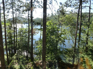 overlooking an expansive view of the lake through a smattering of trees. The lake is surrounded by hills forming a “lake
valley” and the whole area is quite peaceful and quiet except for the sounds of an abundant array of wildlife. Easily
heard were chipmunks and squirrels “arguing” over nuts and many varieties of birds (where is Ellen when I need
her – she could name them all). As evening fell, Caroline and I sat playing games and listening to the serenade of the
loon echoing through the valley. There is no internet nor cell phone service and no TV. Ahhhh…..
overlooking an expansive view of the lake through a smattering of trees. The lake is surrounded by hills forming a “lake
valley” and the whole area is quite peaceful and quiet except for the sounds of an abundant array of wildlife. Easily
heard were chipmunks and squirrels “arguing” over nuts and many varieties of birds (where is Ellen when I need
her – she could name them all). As evening fell, Caroline and I sat playing games and listening to the serenade of the
loon echoing through the valley. There is no internet nor cell phone service and no TV. Ahhhh….. 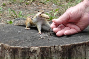 Bill got up a bit later and lit a fire in the fireplace. Oooooo: can life get any better? We enjoyed a morning full of finches,
squirrels and chipmunks snatching peanuts from our fingers before heading into town for a tour of the old Crown Point Forts
at the bridge leading to Vermont. The afternoon wasa spent on the lake paddling about and game playing long in to the wee
hours of the morning. But all good things must come to an end and it was time for me to retire to be prepared for a milestone
tomorrow.
Bill got up a bit later and lit a fire in the fireplace. Oooooo: can life get any better? We enjoyed a morning full of finches,
squirrels and chipmunks snatching peanuts from our fingers before heading into town for a tour of the old Crown Point Forts
at the bridge leading to Vermont. The afternoon wasa spent on the lake paddling about and game playing long in to the wee
hours of the morning. But all good things must come to an end and it was time for me to retire to be prepared for a milestone
tomorrow. and IMC arrived then I flew out of it. No biggie. I made my fuel stop at KJNX and checked the weather. It was already starting
to look iffy on the weather with the afternoon thunderstorms building along the coast and moving to the west. I filed again
flying more to the west than I had hoped ad departed in relatively good weather but a mere 45 minutes into the flight ATC
asks when I got my last weather briefing and suggested that I contact Flight Services for an update. That never happened before.
and IMC arrived then I flew out of it. No biggie. I made my fuel stop at KJNX and checked the weather. It was already starting
to look iffy on the weather with the afternoon thunderstorms building along the coast and moving to the west. I filed again
flying more to the west than I had hoped ad departed in relatively good weather but a mere 45 minutes into the flight ATC
asks when I got my last weather briefing and suggested that I contact Flight Services for an update. That never happened before.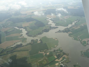 I followed the suggestions and made contact with JAX FSS. That line of storm was developing more fully and quite a bit faster
than earlier forecast and they suggested a diversion 80 miles to the west to Dublin. Much to my chagrin, after checking the
conditions ahead, I saw where they were concerned for my being able to cross the line and I made the turn to the west, landing
in Dublin for the evening. Tomorrow will be a shot flying day and I should be hearing the sweet purr of my little Stubby soon.
I followed the suggestions and made contact with JAX FSS. That line of storm was developing more fully and quite a bit faster
than earlier forecast and they suggested a diversion 80 miles to the west to Dublin. Much to my chagrin, after checking the
conditions ahead, I saw where they were concerned for my being able to cross the line and I made the turn to the west, landing
in Dublin for the evening. Tomorrow will be a shot flying day and I should be hearing the sweet purr of my little Stubby soon.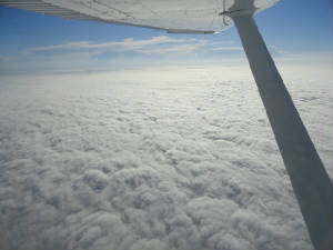 would be no issues in the event of an emergency. I had a slight tail wind and the potential three hours from hell yesterday
turned into a 2.5 hour joy ride home. No storms, no clouds, no stress, rested and happy.
would be no issues in the event of an emergency. I had a slight tail wind and the potential three hours from hell yesterday
turned into a 2.5 hour joy ride home. No storms, no clouds, no stress, rested and happy.
|
|||||||||

|
|||||||||
|
|||||||||

| undefined |
 |
| undefined |

 |
| International Organization of Women Pilots |