|
|
In search of adventure, Wild Mama headed west
toward the mountains. Follow along as we stop in Las Vegas, Glacier National Park, Yellowstone, Mount Rushmore and Crazy Horse.
OUT WEST TRIP JOURNAL July 20, 2006 With a fresh wash and wax spa treatment, Wild Mama was ready for take-off. We departed from X14 this morning at about 0915 in perfectly clear weather and loaded to the gills. Our poor little girl had her butt dragging on the ground with all of the stuff going to Spencer for the new house. We headed off for our first stop in Homer, GA. We had done a great deals report and Homer actually beat out Alma for the lowest fuel price for the area at $3.45/gallon for 100LL. Alma was still at $3.50. Homer was an easy 2:06 flight. The runway was in good shape and easily spotted: just look for the red-roofed church next door and the runway is right there. There was a brand new fueling station and the FBO is in the process of being remodeled but the rest rooms and computer room and fuel were up and running - all the stuff we needed. After our brief stop we were on our way again. For a change we did not encounter a killer headwind. Usually we manage to have a 15 knot headwind in every direction we travel but this time it was limited to 5-8 knots. We departed for Sparta after our fuel stop. We ended up climbing to 8500’ as some thunder storms were building off our right wing tip. Vern and Mario had some good nap times and I was the primary button pusher with “George” (the autopilot) at the helm. We got to Sparta around 1430 local time, unloaded (Wild Mama breathed a sigh of relief) and headed off for La Tapita for our customary Mexican lunch. We are all trying to be half-way good and had fajita salads with chicken - very tasty and only $20 for all 3. With full belly’s we headed off for our house to check on the progress. The stone work is done and all is coming along well with the site work and the trim work. Almost all the lighting is completed as well. We came back to our favorite spot at the Baker residence which we endearingly call the “Baker Bed and Breakfast”. We have been staying here while our house is under construction since October. What a treasure and a pleasure it is to be here. We anticipate sleeping like the dead, as usual, and will awaken in the morning fresh for our next day.
July 21, 2006 Today started out as a beautiful day. Mario has been accustomed to doing his morning walk so Vern accommodated him by getting him a path around the Baker B & B. Mario did his long-legged hoof around the patch and Vern (whose legs are not so long and lanky) did his best to keep up on the straights. He did manage to catch up on the up hill portion where Mario slowed a bit. Anyway, after the walking portion of our program we had breakfast and headed off to pick up the mattress and stuff for the house. We got delayed, as usual, and ended up with a hasty noon-ish departure. Other than the obvious of being late, we were trying to get ahead of the S-64 sky crane which was powering up and ready to depart. We locked our flight plan into the 430 and headed out. We checked the winds which were most favorable at ground level but settled on 4500’. As is customary, we ended up with a 20 knot headwind. We crossed the Ohio River and Arkansas River and dodged a few afternoon thunderstorms. The outside temperature reached 97 degrees F and we flew most of the day in this funky haze. We were hoping for a rain shower to cool and clear the air but no such luck. We were hot, tired and starving as we had forgotten all about lunch in our haste to depart and the snacks (cookies and dried fruits) were not satisfying us at that point. Our planned fuel stop was in KEOS (Neosho, MO). Traffic was landing on runway 19, which seemed strange as the wind was 330 at 12, gusting to 17. I guess we should have waited for a clear pattern then chosen 1, but we landed with a 12 knot tail wind (felt good for a change but the timing was all wrong) around 1600 local time. The fellow at the FBO was ready to leave but he opened the hanger and gave us the courtesy car and the instruction on how and where to leave it. We drove the 3 short miles to town to find a Shoney’s. Being Friday, they had just out up the seafood buffet and boy was it good and appreciated. We actually saw THE $100 hamburger called the Grizzly. And big it was! With full bellies and happy faces we went back to the airport for a proper departure direct to KDHT (Dalhart, TX) for our planned stop for the night. We looked at the winds again for the most favorable (or in our case, the least resistant) and found that buzzing the ground would have worked the best. Being as that was not an option we tries 6500’ and with a ground speed of 118 knots, we opted for 4500’. There we initially ended with 125 knots but much to our surprise WE CAUGHT A TAIL WIND!!!!!!!!!!!!!!!!!!!!!!!!!!!!!!!!!!!!!!!!!!!!!!!!!!!!!!!!!!!!!!!!!!!!!!!!!!!!!!!!!!!!!!!!!!!!!!!! By the time we got to Dalhart we had hit 160 knots ground speed . . . OK, TAS was 150 but hey, a tail wind is a tail wind. The trip out to Dalhart was very pretty - stuff we are not accustomed to seeing in Florida. There were large crop circles which resembled a twister game board but all greens and browns. There were strange pinnacles as we crossed into Texas. We saw feed lots where our local cows get shipped off to. There were beautiful designs carved into the plowed farm fields - laser level artistry. There were small towns which popped up in the middle of vast areas of farm lands, seeming to come up out of nowhere. One of the more interesting things which I noted was the terrain: We checked the elevation of Dalhart which was 3991’ MSL. We figured we would be hitting some hills, mountains or at least a goodly number of bumps in the terrain and there was nothing like that. It was this gradual up-sloping of the terrain like we were climbing up hill the whoel way out. When we looked at the sectionals, we could see some very clear lines of demarcation in the coloration on the charts but figured on that being a noticeable change: it was not, merely a change in the color delineation for the charts. So we kept on getting gradually closer to the ground until we had to climb up past pattern altitude so we could prepare for landing. Dalhart is in the middle of nowhere so it seems. Lots of farms, cows and a small town full of wonderful people. We had seem on AIRNAV that the place we wanted for fuel, Bailey’s, was at the end of runway 17. So we taxied over at almost 2000 hrs local time and there were a couple of fellows still there. They ushered Wild Mama into a hanger for the evening in case of a storm, gave us the company courtesy car and directed us to town for the evening. We snagged a Best Western for the night happy like clowns. The town of Dalhart is smaller than the airport. There are more hotels than anything, a few fast food places, a couple of restaurants and lots of friendly people and cows. Probably more cows than people. We went to a local truck stop (only thing open) and got some water for the next days’ journey and retired happily back to our room.
July 22, 2006 Since we had noticed the surrounding terrain to be quite flat, we decided a pre-dawn departure was in order. Had we been in the mountains we would have had second thoughts about dodging the rocks in the dark, but we had not concerns about the cows. What a treat!!!!!!!!! Apparently, there is a lot of crop dusting in the area (Baily’s Flying Service being one such company) and the locals have marked their silos, towers and other obstacles with strobe lights - and lots of them. As we departed, climbing out to 8500’, the whole area seemed to be illuminated with these “fireflies”. We continued on past Albuquerque, NM with the sunrise at our tail chasing us all the way. It finally caught us as we crested the ridges east of Albuquerque. . . And a beauty it was. The sun started shining off the rock formations and mountains giving us a color show that entertained us and reached its climax in Sedona, AZ. We circled the area prior to landing to snap a card full of pictures of the formations off the north end of the runway. The images were nothing short of spectacular and there was no doubt in our minds why this is the most scenic airport. The view, however, was only half the fun. We actually got to land at Sedona (or USS Sedona) as it is called. The airport sits atop a mesa at an elevation of about 4900’ msl with a drop off on both ends. If you go to the web site for the Sedona Airport www.sedonaairport.com you can view their photo and get a better concept of the USS Sedona. (Better yet - make this trip yourself.) The wind can be a bit squirrelly and the locals seemed to define a “calm wind” as anything under 10 knots but do not let that scare you off. Vern made the first approach and landing as I was way too busy snapping pictures to be bothered with such a silly thing as landing the plane. The remainder of the treat of Sedona was the friendly people and great service. We got a rental car for about 2 hours for $20. Can’t beat that. We drove around town just enjoying those Killer Views and hospitality. We missed the Sedona Airport Cafe as it was closed for remodeling but anyone else going there will find it open again after August 2nd. Then we had to depart. Before we left, we noticed where you could get a USS Sedona official landing certificate for $2.50. Could not pass that up - a real bargain. So I had to make a landing myself. We departed on 21 amidst a bunch of traffic - and here comes the part about the calm winds. The winds (from our point of view) favored 21 for takeoff and landing, but the local custom in land on 3 and depart on 21 in “calm winds”. Winds were 8 knots and there were, apparently both locals and non-locals having a lively discussion on the radio about the proper runway etiquette. After a bit of a delay, I took off and made a circle around the patch and landed on 21 with a full stop. Not the place I wanted to practice touch and goes with a density altitude of 7900’ msl. I made a full stop landing and a very long roll out and Vern had to do the second departure to complete his carrier quals. This gave me the opportunity to hang out of the photo project again. It was quite exciting to watch the take off as well .As one of the local FBO employees aptly stated: ready or not, you will become airborne if you roll far enough. After departing the area we got flight following for the trip into Las Vegas as there are warning about the amount of air traffic and the air congestion. Even this turned out to be quite entertaining as we managed to have our very own air traffic tour guide on our approach into Henderson, NV. We had skirted the fringes of the Grand Canyon controlled area to snag whatever views we would. We had planned an arrive via airways over Lake Meade with the hopes of catching a gander at the Hoover Dam. Being unfamiliar with the local area and customs and with the security after 911, we did not want to linger too long over the Dam. Much to our good fortune, a rather quick-witted controller noticed out circuitous route to get to Henderson and asked if we were familiar with the area. When we replied “Negative” he commented that he though as much as we were heared to Oregon enroute to Henderson. He turned us on a 240 heading and flew us directly over top of the Dam. We made a slight sachet to the left so Vern could get a photo opportunity. Not even this went un-noticed. We suspected that there were bets going on as to whether we would stay on course or not to get the photo of a lifetime. They granted us permission to circle the Dam which we declined and continued on into Henderson. After getting our rental car, we made a beeline to take the tour of the Hoover Dam. This was well worth the trip. We saw the generators, a water diversion tunnel and much of the history of the Dam construction and the benefits it brought to the area. The traffic (by car) was quite heavy but we would have gone again even if the traffic was worse. We came back to Las Vegas for dinner at Toby Keith’s I Love This Bar and Grill inside of Harrah’s. My favorite place for baby back ribs but be warned: bring you appetite or a doggy bag because the portion is huge. Also, do not miss the pecan sweet potato pie with Bourbon ice cream and be prepared to waddle out the door. We ended this night watching the shows along the Strip and crashing into bed at 10:00 p.m. local time. I don’t even remember my head hitting the pillow!
July 23, 2006 We finished out the day with probably one of the best steak dinners we have ever had right at the Flamingo Hilton. Their restaurant is “Steakhouse 46”. I guarantee you it is $$$$$ but it is well worth the money for a really good meal. The bill for 3 was $153 plus the tip but, again, worth every finger licking penny. We ended the day early with a brief walk around the Strip of Las Vegas again. Being Sunday, there were not the hoards of people as we encountered last night and the heat was down considerably. But, being as we had trip reports to write and we need to get an early start for the morning flight to Kalispel, MT, we wanted to retire early and be somewhat rested. We anxiously await the flight over the Rocky’s enroute to Glacier National Park tomorrow.
July 24, 2006 Today was the day we started getting into some real rocks. Anything over sea level for us Floridians is nose-bleed high. We did out initial climb out to 9500’ msl. We got flight following up and out of the Las Vegas area and had hoped to maintain contact through Salt Lake area. Just before Salt Lake, we hit a ridge line where ATC lost radar contact and soon radio contact. We changed direction of flight and climbed to 10,500 msl to give adequate ridge clearance. All and all, we had no winds and glass smooth air for the greater part of the trip today. The airways were mostly in the valleys, much of it following Highway 15 from Las Vegas to Salt Lake and on up into Missoula, MT. We had a few small deviations for TFR’s for wild fires but virtually none for terrain. The mountain scenery was spectacular. We flew past some snow capped peaks, valleys with towns nestled in the arms of the mountain slopes, mountain lakes, and vast areas of farm lands and open spaces. We became quite amused by the Sectionals listing landmarks such as “building”, “house”, “farm”, “Plant”, “Letter E” and the like. But once we saw that there was literally nothing there other than an “E” or a house, etc., navigation became quite easy. My niece, Brenda, a pilot out of Afton, often commented that she did not know how I could navigate all the featureless flat lands of Florida. Her comment always seemed odd to me until now. Florida has too many features - too many towns, roads all over the place, lots of small lakes and rivers. It is the lack of abundance of features which actually aided in the navigation through the area. We landed for out fuel stop in Pocatello, ID and were greeted by some very warm, friendly people who readily topped us off, offered us fresh baked chocolate chip cookies and good conversation. After a short break we departed for the “real mountains”. Again, we climbed to 10,500’ msl. We had gotten the METAR from the MX20 and noted that the cloud cover was 11,000’. I guess that sounded great to my Florida ears thinking I was flying at sea level. But the reality was that the ground was up around 8,000 to 9,000’ most of the way so 11,000’ msl left us a slim, but very beautiful, path to fly. The whole day was brilliant blue skies except for a small rain burst over Dillon, ID. We came into KGPI - Glacier International - descending over Flathead Lake, with the snow peaked mountains to our right and the lake shore off to our left. There were times when it was a real toss-up whether to fly or snap pictures. Fortunately, the new S-TEC “George” as we call him, flew on my behalf while I took pictures. The timing to put in the vertical speed command and altitude pre-select was perfect. I must say it has been well used already. We landed at KGPI and were greeted with our rental car - pre-arranged through the FBO Edwards. They topped of Wild Mama and put her to bed for the next two nights. So with out little girl secured we ventured off to explore the town of Whitefish. Here we find a small town, with wonderful people and stunning scenery. Everywhere we turn there are flowers planted or potted - a color feast for the eyes. The homes - many log homes - are perched on the hill sides taking in the vistas before them. Our lodge, Grouse Mountain Lodge, was no exception. We came in tired this evening from a nearly 6 hour flying day - all at higher altitudes. We look forward to a good nights’ sleep this evening then up tomorrow to explore Glacier National Park before our departure for Yellowstone on Wednesday morning. Photos start with the sunrise over Las Vegas and the vistas enroute; our fuel stop at Pocatello, ID; our approach into KGPI and the views of the town of Whitefish and the Grouse Mountain Lodge.
July 25, 2006
We entered the park on the west end next to McDonald Lake. The water was so still that the distant mountains were mirrors in the lake. The duck were underwater fishing, popping up to make the only ripples you could see. There were beach areas at the various pull offs next to the lake where you could access the ice cold water. The beaches were not sand, but a bed of multi-colored little stones well worn by the water action over time. They were easy to walk on without hurting your feet at all. The whole road through the park should have taken about 2 hours if you did not stop. We made the crossing in about 6 hours. We stopped by the various “exhibits” as they were labeled, admiring the breath-taking vistas of the glaciers, other snow crested peaks and the cedar trees which are prevalent in the park. We crossed the Continental Divide, which I am embarrassed to say I could not remember why that was significant, although I am sure I learned about it somewhere in my past education. For those others who have forgotten, never knew or were absent that day in class, the Continental Divide is the line in this continent which separates the direction of water flow either to the Pacific, Arctic or Atlantic. There is actually a point at Glacier National Park where the flow goes to all 3 bodies of water from that location. We climbed what seemed to be forever on a road that was artfully perched along the mountain side, winding its way up through the trees, mountain sides painted with wild flowers and various rock outcroppings. The Road to the Sun took us up past Heavens Peak at some 8800’ and on through Logan’s Pass at 6646’. The pass was actually the highest point we were able to access as the other peaks were just there to admire from afar. We took the Cedar Trail which was a boardwalk of cedar through a huge relatively flat cedar hammock. We hiked back nearly a mile to one of the many water falls which dot the park, this one emptying into St. Mary’s Lake. Although the day had started out at a cool 65 degrees, it heated up to 96 by the end of the afternoon as we left the park for our hour long drive back around the park from the east gate to our lodge in Whitefish. By early evening, the temperature was cooled considerably to the mid-70’s. Funny things you don’t think about . . . Sunrise happened around 5:30 a.m. local time and sunset happened somewhere near 10:00 p.m. As we are so far north. Really long days with which we from Florida are not accustomed. Our day ended with plans to try to over fly the park before our departure for Idaho Falls tomorrow.
July 26, 2006 We started with the sunrise over Glacier National Park. It was a dead calm wind day with the big, blue sky of Montana hovering over us. We knew it would be a nice day for a flight over the glaciers when we saw the hot air balloon rising over the airport. We headed off doing a steady climb out to 13,700’ msl to make the peaks and flight rules over the park. Fortunately, the temperature was about 58 degrees on the ground and about 36 degrees at 13,700’ so we actually had some performance out of Wild Mama. The flight over the park was magnificent! We crossed McDonald Lake, Jackson Glacier, Logan Pass Visitor Center and St. Mary’s Lake. We then departed to the south toward Missoula and on down to Idaho Falls where a little treat was waiting for us. The trip down was filled with more mountain views and lots of wild fires, with TFR’s popping up all over the place. Unfortunately for us, the TFR’s on the MX20 picked today to go down so we had to use the old fashioned finger and chart method of figuring out not to fly. Seems that the Husky plant is located in Afton and, although most planes have departed the area for Oshkosh, there was one lone Husky left in Idaho Falls waiting for us to take a demo ride. Talk about fun. Vern took the first ride. I was standing on the ramp with a view of his departure partially blocked by a few jets. I knew something was up, however, when he made it off the ground and in the air between the 4,000 and 3,000’ runway signs. He returned an hour later sporting a healthy grin. Then it was my turn. This was my first tail wheel experience, and, oh, what an experience it was. I think the grin comes as standard equipment when you fly in the Husky A-1B. If we used 300’ of runway roll before rotation, that was a lot. That plane will fly!!!!!! We made a few touch and goes in the local farm field runway; we did some steep turns, climbs, slow flight and pushed the aircraft to both ends of her performance spectrum. What a blast. I returned to the airport an hour later sporting that same grin. After our little test flight we headed on to Jackson Hole, WY to spend some time with my sister and her family. Now er got to do some real eyeball and finger mountain flying. The peaks were park of the Grand Teton Range and sprang up to over 13,000’. As we departed Idaho Falls with a temperature of 106 on the ramp, our density altitude was nearly plus 4,000’ so we knew an over flight was not an option. We checked the sectional and found a river and a road leading to a reservoir, then a skinny little Teton Pass going into the valley which is Jackson Hole. It was quite a bit bumpier than our other flights as the day was really starting to heat up by now. We dumped out into the Valley and realized the airport was right there and we had 3,000’ of altitude to lose in no time at all. The tower set us up on a left downwind for 19 and with the shift of the wind we were told to do a right 360 and come in on a right base to 1. This gave us just the time we needed to lose all that unwanted airspace below us and drop in for a landing on runway 1. The scenery off to the left of the plane was the Grand Teton Peak and the whole range along the side of the airport. What a view. My niece, Brenda and her daughter, Jerri, greeted us at the airport. We headed off for some food as we had not eaten since 4:00 a.m. Local time and it was now close to 2:30 p.m. We stopped in Bubba’s for their pulled chicken, beef brisket and salad. Yummy. Good food, friendly people and that wild west atmosphere surrounded us. After lunch, my other niece, Dee-Dee, fetched us for the ground tour of the Grant Teton National Park where we were treated to more spectacular views, glaciers and our first glimpse of the animals. We saw moose, buffalo and antelope. We stopped at the Luton Teton Ranch visiting in-laws and admiring more views. We finished the day with a steak dinner at the Teton Steakhouse and a long drive to Brenda’s house where we completely died of exhaustion for the night.
July 27, 2006 The tour continued with a hearty breakfast at the Virginian Restaurant in Jackson Hole. The placed was packed for breakfast even at 10:00 a.m. When we got there (we finally got a lazy start to the day). First and most importantly about the Virginian . . . Bring your appetite. The portions where HUGE and very good. We had pancakes, various versions of omelets and eggs. The bill was quite reasonable for 4 people. A definite MUST STOP again. We had actually tried to stop there for lunch yesterday as we heard it was so good but the place was closed for a few hours in the afternoon. We landed at my sister’s house for the family visit and proceeded to the town for a walking tour and shopping. I have been looking for some interesting stuff for the house in Tennessee and found all sorts of antler artifacts, skins and all sorts of little goodies. We stopped at the Cowboy and admired the unique bar stools and wood work. The day was a typical Bahamas type of severe clear - not a cloud in the sky and nothing but blue enveloped us as we hopped in Wild Mama for a tour of the Valley. We departed Jackson Hole with a 10,000’ density altitude and a plane load of four. Knowing the heat was a killer this afternoon - we emptied the plane of everything that was non-essential. With ten degrees of flaps we still ate up every bit of 2,500’ of runway before we were off. We climbed out past the Tetons and on through the pass above the Snake River and Route 89 where we drove up this morning, south to the Palisades Reservoir. What a view. I am not sure if it was better fro the air or the ground. We over flew Alpine Airport and on to Afton. We passed some homes which made us do a quick 180 to double check our eyeballs when we saw the castle! We finally landed back at Alpine as a TFR will be thrown up at Jackson for the secret arrival of the VP soon. Alpine is a 5,600’ public runway - very nice - off the end of the Reservoir. Beware as it is a very skinny runway and deceptive. We settled in for a nice steak dinner and some relaxation this evening.
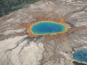
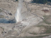
July 28, 2006 We passed Teton National Park enroute to Yellowstone and the Grand Teton shone in all its splendor against the brilliant blue sky. Brenda pulled out at a little spot on String Lake to give us our first vistas. The lake was glass flat which made the mirror reflection of the Teton range shimmer in it glory. The rich blue of the sky and deep green trees contrasted with the stark browns of the towering peaks giving our eyes a wonderful morning wake up call. We continued on up to Yellowstone where we passed elk in velvet near Grant Village. There were herds of buffalo dotting the landscape everywhere we went through the Park. It was obvious that they owned the place as the swaggered across the roadway, making the tourists wait and watch. The moods of Yellowstone changed with each corner. There was still evidence of the devastating fires of 1988. The new growth forests with small pines were littered with the burned remains of the one towering giant pines which stuck out of the tops like a sea of toothpicks. Turn the bend and you were enveloped by lush green meadows airbrushed with wildflowers and drizzled with queen anne lace. Animals grazed by the road side in Hayden Valley. Then out of hills came the grizzly bear. What a treat! He wandered past the stream ignoring the throngs of on-lookers who were pulling off the road to catch this rare site. Another turn brought the first sighting of Jackson Lake with the mountains in the backdrop of more mountains. Then came the mud pots, spitting and bubbling. The geothermal region was yet another face which showed its moods with each glance. The mud volcanoes - like dragon’s breath - hissed and spit; there were steam vents which simply shot a steady stream of super heated steam. Then the landscape changed again and we entered the Grand Canyon of Yellowstone. This feature really caught me by surprise. As we wandered down the path, you could see the sheer walls of the canyon. What you cold not see was the waterfalls and the river which had been working its lifetime to carve the canyon. As I turned and saw the falls, I was completely overwhelmed by the majesty of this site just tucked away in a little corner of the Park. We stopped for a quick late lunch at the north end of the park. We had not yet gotten to the “good part” as Brenda commented. Old Faithful and the geysers were yet to come. We turned back and headed south back into the geothermal region past fire hole falls; more meadows, hillsides and breathtaking vistas. Our first view of the geysers was quite a show with a fountain geyser. We continued on with geysers erupting a stopping with the seeming push of a button. Some eruptions lasted quite a bit and others were gone before you could get the camera turned on and aimed in the right direction. Our heads were spinning in all directions trying not to miss a single event. Our last stop was at Old Faithful. The eruption was scheduled for 8:12 p.m. local time, plus or minus 10 minutes... And right on schedule she blew, shooting water 60 or 70 feet into to the air. You could hear all the oooohhhhs and aaahhhhhs of the crowd which had gathered in the large seating area which surrounds the geyser. After this fabulous show, we grabbed some dinner at the Old Faithful Inn and Cafeteria and headed back south to go home. We all crawled in just past 1:00 a.m. In the morning and crashed into bed. We have an early wake up call for our flight over Yellowstone in the morning.
July 29, 2006 We were off in a flash and meandered our way through the mountain passes and around the TFR areas. These mountains, which once seemed so intimidating from the comfort of our sea level homes, have become familiar friends in the cool early morning clam. We crested the ridge and entered Teton Valley on the back side of the Teton Range. We flew up the valley past Driggs Airport and on to West Yellowstone. As we were well oriented from our travels of yesterday, we followed the roads in to the park from the west entrance and on to my beloved canyon. I had been so overcome yesterday at the ground level sight of the canyon that I had to see it by air. It was no less spectacular. We could see both the upper and lower falls and the sunburst of colors which lined the sheer cliffs. The mist from the water wafted from the falls and joined the haze which had greeted us from the nearby wild fires. We did not have that rich blue sky from yesterday, but the haze and scattered cloud covering offered us a different perspective of this Park of many faces. We followed the road down to Yellowstone Lake, past the Fishing Bridge and the resort and massive camping areas. We circled back past the mud pools and geothermal features which were littered with buffalo today, and on around toward Old Faithful. We passed the eye in to the world, a cobalt blue pool with its blood shot rust stains running in to the whites of the calcium deposits which surrounded it. Then, as if on cue, Old Faithful came into view and erupted, treating us to the hydrothermal shower spectacular. We departed the park happy with our final show and headed off to Driggs for lunch at the Warbirds Cafe. As we had arrived a bit early for lunch, we went through the exhibit in the hanger attached to the FBO and saw the L-39’s, T-2 Buckeye, Aerospacelle Llama Helicopter, the T-28 and the WWII era bi-plane. We had a light lunch of salads and fruit, the portions of which rivaled those of the Old Faithful Cafe last night. We finished our day with some family time, shopping, good food and a stunning sunset for our goodbye from Wyoming.
July 30, 2006 We determined that the best pass was one just off the runway to the east. As there was a small hill - about 1500’ agl in front of us, we departed and made a climbing right turn to gain the altitude we needed to avoid the hill immediately off the runway and to enter the pass with enough height to avoid problems. We went to the tried and true finger and eyeball method, identifying the blind passes to avoid as well as the potential best routes as we continued our climb to 11,500 msl. It started to rain. We had the MX20 on the split screen with the weather and terrain and used all available resources to avoid the more dense rain and to select the best pass to maneuver through to make the crossing to Big Piney from Alpine. After about half an hour, we cleared all the major obstacles and set the auto pilot for Rapid City. After the beautiful mountain scenery of Yellowstone, the next part of our journey was rather bleak. Vast expanses of dirt and featureless rock with an occasional burst of color, trees or some other interesting feature. But for the most part there seemed to be a lot of wasted space. We consulted our road atlas which we had collected before departing Florida in the event we needed additional finger and eyeball directions. This time it paid off as we were able to pinpoint the location of both Crazy Horse Monument and Mount Rushmore. We approached Crazy Horse from behind then caught a glimpse of his profile. The monument from the air was quite impressive. We circled on toward the east and headed off to Mt. Rushmore. Again, we snuck on the monument from behind and had to circle to get the full picture. The presidents’ faces stood century over the valley and the black forest beneath it. We landed at a very hot and smoky Rapid City. We were put onto an extended downwind and really had to search for the runway by the time the controller called our base leg. The temperature at 10:30 a.m. Local time was creeping up over 100 degrees. We were happy to be on the ground by them. We snagged our car and explored the monuments which we had just seen by air and continue on to the Black Forest and Custer State Park. Custer was a real contrast to the Yellowstone. There were large granite rock formations through which an ingenious highway engineer with a sense of humor fashioned a road out of what was once a very small lizard trail. There were narrow tunnels cut through the granite where barely one car could pass along Needle Road, which wound its way down the hillside to the drought stricken meadows below. The rivers were gone leaving the dry beds in their place. We were actually quite surprised to see many herd of Pronghorn deer grazing and sleeping in the hot sun, and wild turkey running amuck across the streets and into the roadside brush. It was a relaxing drive and a lazy afternoon for us as well as the buffalo, most of which were resting from the heat of the day. We returned back to the little town of Keystone where we are spending the night. Tomorrow we will be going back to Tennessee to spend a few days working on the cabin to have it ready for rental for leaf season before our last leg home to Florida. We have picked up a few unique trinkets along the way and are anxious to put the finishing touches on the house when we get back. Tomorrow will be the last trip report as well. We will be crossing the great plain states enroute to Tennessee.
July 31, 2006 When we got to the airport we noticed something was amiss when Wild Mama had the wheel chock missing from the front wheel and she was turned a bit. When we stepped out on to the ramp we realized that the wind had picked up quite a bit that morning - 31 knots gusting to 40 knots. Fortunately, it was blowing straight down the runway. This made for quite an interesting take off but an even more interesting taxi to the departure point. The sound of the wind rushing backwards over the control surfaces was deafening and you could feel the plane rocking and shuttering as we made the abbreviated taxi to A3 on runway 32. We felt like we were back in the Husky taking off as we were in the air after only about 300’ with an airspeed of 90 knots and a ground speed of 38.4 knots. We made our climb out thereafter without incident. We crossed over part of the Bad Lands back on track to the east. We noticed how the landscape was making the dramatic changes again. There was one point where there was a definite line of demarcation on the landscaping. We selected Centerville, Iowa as our fuel stop as it was near the half-way point and there were quite a few good reviews on Airnav. We asked for “Kathy the Airport Goddess” and found her. Kathy is the airport manager and just as sweet and helpful as can be. We started to ask for the courtesy car to go for lunch but she made us sandwiches of ham salad, chicken salad and home made zucchini bread. Then she loaded us up with fresh vegetables from her garden for the trip home. She treated us like we old friends and I could see why Centerville got such good reviews. Around 1400 Zulu we crossed the Mississippi River and we knew home (in Tennessee) was not much farther. We started thinking about all the miles we covered - 6027 nm in all for our adventure. We talked about the what we learned on this trip. I am still a new pilot in terms of years - I have only been flying 16 months. But enoute to Mt. Rushmore, I crossed the 400 hour mark. This, for me, was the trip of a lifetime in a small plane. It was a learning experience. I learned that mountain charts wear out a lot faster than charts of the flat lands. I learned that a big trip is just a series of small strip all strung out and put together. I learned that people will always make you feel at home if you give them the chance. As my 9 year old niece pointed out, a forest of trees really does look like broccoli. I learned that a red roof is the best landmarks from the air. I learned that you can read the winds from the cornfields as well as you can read them from the lakes and smoke. I learned that it does not really matter where you go; it matters THAT you go because even someplace in the middle of nowhere is some place interesting to see. This trip was about the incredible journey, punctuated by fabulous destinations. We, as general aviation pilots, have an incredible opportunity to see our world from a different perspective. It is an opportunity we should not waste. It is difficult to get 2 weeks to take the kind of trip which we just had - but even starting wherever you are and making a weekend trip wherever the tail wind takes you is a good start. The please be sure to tell everyone about it because everyone and every place has something to offer if we just go look for it. Thank you all for sharing our journey. |


|
|||||||||

|
|||||||||
|
|||||||||


| undefined |
 |
| undefined |

 |
| International Organization of Women Pilots |