|
Wild Mama captures 3rd place in Okie
Derby 2007. PHOTOS FROM AUGUST 16TH: X14 - KMGM August 16th: The plan today was for an early morning departure from LaBelle. Check. Wheels
up at 0645 hours. The sunrise was stunning. Tower: “Roger 4-Whisky-Mike. Runway 21 cleared to land.” Vern say
he will make the landing, promising to do as little damage as possible. He pulls back on the yoke. Power, power. We cross
the intersection and the runway is ours. This would be your classic “Ed Wilson” landing. Hold her off . . . hold
her off. Easy on the mains. Vern cuts the engine to avoid a prop strike and drops the nose. The fire trucks are rolling behind
us. The gear held. A big sigh of relief.
August
17th: What a difference a day makes. We all got a good nights sleep and were ready to face the day. We arrived early
at the maintenance shop in time to catch a little pre-work show. A lone F-16 was heading out only to return shortly. Vern
was hard at work, while Mario sat and I paced like an expectant father awaiting the birth of his first child. At last, like
an alarm went off, the long awaited parts arrived on schedule, and Vern was able to complete his repairs in short order. A
quick gear check and all was well with the world.
 In a flash we were off and ready to go - wheels up at 10:30 - much sooner than expected. We had joked yesterday that
something was wrong because we caught a tail wind most of the mornings flight. Well... Today we were faced with a new day. We
were just happy to be repaired so quickly as we had been quite concerned that we would not arrive in Oklahoma City until
late and the reminents of theTropical Storm were heading northward through Texas. In a flash we were off and ready to go - wheels up at 10:30 - much sooner than expected. We had joked yesterday that
something was wrong because we caught a tail wind most of the mornings flight. Well... Today we were faced with a new day. We
were just happy to be repaired so quickly as we had been quite concerned that we would not arrive in Oklahoma City until
late and the reminents of theTropical Storm were heading northward through Texas. We checked the winds, trying to make the best of them all. We want to make an effort to maximize whatever winds we are dealt today. We shoot for 8,500' but the haze is too thick to climb so we settle for 6,500' and a nice 15 knot tailwind again.  We are pleased. The haze persists. As we approach the Mississippi/Arkansas line, the blanket of haze which has nearly
enveloped us through the day begins to thin to reveal ribbons of rivers meandering through the canvas of American, painted
with the rich earth tones of a fertile ground. We are pleased. The haze persists. As we approach the Mississippi/Arkansas line, the blanket of haze which has nearly
enveloped us through the day begins to thin to reveal ribbons of rivers meandering through the canvas of American, painted
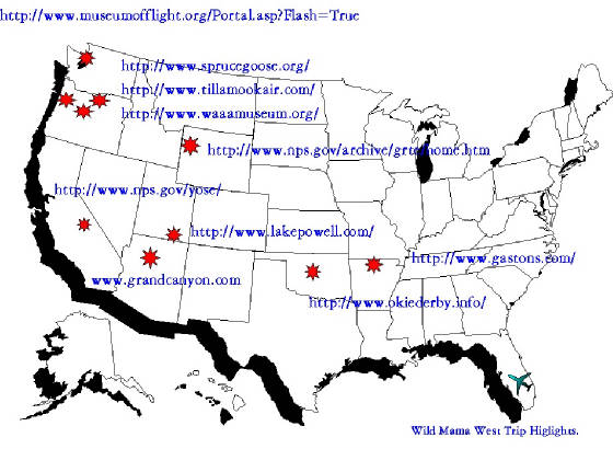
with the rich earth tones of a fertile ground. As we had radar service leaving Montgomery, we elected to keep it and just maintain flight following all the way through to Oklahoma City. We darted around the hot MOA just outside of Mongomery then set course direct to Wiley Post (PWA). As we made our turn more northward, our tailwinds increased, at one point pushing us past 170 knots in level flight. The clouds start to build from the daily heating and we are forced to climb over them, losing some of our favorable winds by then. We cross the Mississippi River. Tugs are hard at work, pushing their massive barges against the flow. I look at the GPS and gaze back to the ground in amazement as the picture of the GPS, the contours of the river, the nuances of small islands, curves and the like, are the identical twin of what I see on the ground. Oklahoma City is now in sight, and a beautiful sight it is. We never got to see the City when we arrived for the race, solidly in the soup. We see Tinker, Oklahoma City downtown area, the OKC airport and finally, Wiley Post comes in to view. We are high and fast, now descending at 170 knots. I snatch back on the yoke and raise the nose. "Drop the gear. Ten degrees flaps." Vern is right there. Done. Nose over and dive. We are cleared to land, entering on a left base. Nose up again, bring her into the white arc. "Dump full flaps." We dive for the runway and ease her on in. No fanfare. No fire trucks. No worries. As we move on to the ramp, we see our friends, Poochie comes for the photos, Phil, Teresa. Then we see Rita, Ann, Crazy Phil. They are all here. We feel at home - so many familiar faces, so many friends. That's why we are here. . . the Okie Derby just provides the excuse. We unload, refuel and complete our registration and plop down to indulge in the spread put on by the OKC 99's. We so enjoyed their company and hospitality before the 2007 Air Race Classic that we really wanted to come back for a visit. It is good to be here. A quick rest at the hotel and we ready ourselves for the pre-race meeting this evening. The course is not disclosed until tonight. From that point we have to do our computations to figure out how long it will take to run the race - TO THE SECOND! The we look at the forecast winds, the course, headings, altitudes and tomorrow morning before we depart, we declare our fuel consumption to the tenth of a gallon. We are told that it is not uncommon for the winning plane to nail the time and be off only 1/10 of a gallon on the total fuel consumption. Wow! Sharpen your E6B and get to work. Stay tuned. . . the whole Okie Derby event will be revealed tomorrow. PHOTOS FROM AUGUST 17TH: MGM - PWA August 18: Mother nature gave us quite a scare
this morning as the weather was MVFR then IFR for the Okie Derby causing a last minute route change.
 We had been given the route last night (PWA-F36-3OK1-PWA). The route was 198 miles and we made our fuel and time calculation.
This morning, the weather forced the change to fly more toward the east as the western locations were solid IFR. After a delayed
start, a new route was announced at 0915 hrs: PWA-3OK1-JWG-SUD for a distance of 207 miles. We now have to scramble to re-calculate:
19.2 gallons and 1 hour 28 minutes 43 seconds. The start was set for 1000 hours. We had been given the route last night (PWA-F36-3OK1-PWA). The route was 198 miles and we made our fuel and time calculation.
This morning, the weather forced the change to fly more toward the east as the western locations were solid IFR. After a delayed
start, a new route was announced at 0915 hrs: PWA-3OK1-JWG-SUD for a distance of 207 miles. We now have to scramble to re-calculate:
19.2 gallons and 1 hour 28 minutes 43 seconds. The start was set for 1000 hours.Wild Mama departed as Okie Racer 3. A burst of speed, set the throttle and tweek the mixture, trying to get the perfect flow of 13 gallons per hour. We depart with a tail wind and whiz to our first fly by. We scribble the marker and get the spotters to spot us. We do a little lolly-gagging as we see we are really fast. On to check point #2. Again, we are really ahead of schedule so we run a full pattern, get the marker, run a full pattern out and head east. Still way ahead of schedule. We head for Stroud, the last point. We pass by oil wells and vast farm fields throughout the countryside north of Oklahoma City.  Time is good. Fuel burn is excellent. We do the fly-by and collect our marker. We turn for home. Time check: What??? We are
now 2 minutes behind schedule! We turn on the after burners and pour the coal to her, Vern carefully adjusts the mixture so
as not to completely choke off the engine, but still keep out 13.0 gallon burn. We had planned on diverting north of the tower
farm to kill time but now we have to go through. The biggest gap is between tower 2 and 3: we aim for the hole and call Wiley
Post Tower. We are really tight on time and try to come in direct. We are directed to fly north of the airport then
come around over the lake to the southwest before turning on downwind. Oh, NUTS!! That blows our time. We need more speed
but cannot choke off the engine any more than what we are. Cut it close. . . 20 seconds . . . hard bank to the left and dive!
We see the timing line and "click". We are close, but over. Dratts! OK, lets land and cut the fuel: we have burned
too much with that headwind we encountered. Time is good. Fuel burn is excellent. We do the fly-by and collect our marker. We turn for home. Time check: What??? We are
now 2 minutes behind schedule! We turn on the after burners and pour the coal to her, Vern carefully adjusts the mixture so
as not to completely choke off the engine, but still keep out 13.0 gallon burn. We had planned on diverting north of the tower
farm to kill time but now we have to go through. The biggest gap is between tower 2 and 3: we aim for the hole and call Wiley
Post Tower. We are really tight on time and try to come in direct. We are directed to fly north of the airport then
come around over the lake to the southwest before turning on downwind. Oh, NUTS!! That blows our time. We need more speed
but cannot choke off the engine any more than what we are. Cut it close. . . 20 seconds . . . hard bank to the left and dive!
We see the timing line and "click". We are close, but over. Dratts! OK, lets land and cut the fuel: we have burned
too much with that headwind we encountered.We land, taxi and cut the engine. Vern has to re-fuel.  They throw a towel over the gauges so we cannot see the results. When Vern is done, we look . . . 19.8. Not too bad. We are
pleased. But how well has everyone else done and what was our "official" time. We find out tonight! They throw a towel over the gauges so we cannot see the results. When Vern is done, we look . . . 19.8. Not too bad. We are
pleased. But how well has everyone else done and what was our "official" time. We find out tonight! Well, the scores came in and Team Wild Mama took 3rd place with a 6/10 gallon fuel overage and a 8 seconds time overage. We were very pleased. In addition to 3rd place overall, we received Best 99; Best out-of-State team; Best First Time Finish! Congratulations to all who ran the 2007 Okie Derby. We all had a great time! What a day! PHOTOS FROM AUGUST 18TH : OKIE DERBY 2007 August
19: The theme of this trip so far has been "what a difference a day makes". Although we planned an
early morning departure, the remnants of TS Erin delayed our flight out until nearly 10:30, jeopardizing our chances of getting
to Page, AZ by days end.
 Finally, with I-40 closed, flash flooding in Watonga (one of our checkpoints yesterday) and winds gusting to 43 knots, we
were able to make our way to the airport to try to get out. Although we wanted to make the whole trip VFR, the only way out
was to file IFR and leave with radar service. If all goes well, we can cancel before long. Finally, with I-40 closed, flash flooding in Watonga (one of our checkpoints yesterday) and winds gusting to 43 knots, we
were able to make our way to the airport to try to get out. Although we wanted to make the whole trip VFR, the only way out
was to file IFR and leave with radar service. If all goes well, we can cancel before long.Once off, we climbed as we saw the rivers overflowing their banks; roads were indistinguishable from the farm fields which they served. Everything, so dry yesterday, was a mess. We climb to 6,000' where we encountered the ceiling of clouds. A very thin layer EXACTLY where we needed to be. What a difference a day makes. To add insult to injury, we had headwinds initially between 20-30 knots which made the slog through the soup that much more irritating. So much for seeing the counrtyside. Finally outside of Tucumcary, we had to climb and the cloud layer thinned to nothing and we got our visibility back . . . and lost most of the headwinds as well. We passed by windmill farms and small towns dotting the ever browning earth. The farther west we flew, the less green we would see until the ground sported the various hughes of rust and brown. We decided to keep radar service on through to our planned fuel stop in Santa Fe, NM. We could keep it no longer than that as the density altitude at 10,000' where we were flying was already 12,500' and we would have had to climb another 2,000' to keep radar service after Santa Fe. Coming in to Santa Fe was a real challenge. Although the winds did not seem to be very high, we learned a new meaning to the word "variable": one minute we were tail up and screaming downhill at 165 knots, then the next minute we were barely creeping along at 96 knotts, rocking and rolling the whole way. The Santa Fe tower was a welcome sight.  We decided to go get some lunch, study the next leg of the route to Page, AZ, and relax for a while, deciding when would be the best time to go. We were not fond of attempting high mountains in the heat of the day but the skies were slightly overcast and we were only in the mid to upper 80's. Maybe this will be doable. The airport personnel recommended a great little place called the Blue Corn Cafe featuring southwestern style specials including New Mexico Sheppards pie and blue crab cheese dip. We all thoroughly enjoyed lunch waddling out like stuffed tics. We traced out a route which would allow us to fly at a maximum altitude of 8,500' so we decided to make the run for it. The winds were reasonable, a few scattered clouds and not the blistering heat which had been present a few days before. The next leg of the trip made us think back to the early days of aviation where pilots in open cockpits tried to study some sort of map or chart with their heads planted firmly outside the cockpit. We were to follow some powerlines through a pass and a valley, pick up the 134 radial off of Rattlesnake VOR, then follow the road to Bluff where we would pick up the river and Powell Lake on in to Page, AZ. Sounds simple. Notes to self: (1) brown powerlines are not easily visible against a brown background; and (2) VOR receiption is bad through a mountain. Plan B. Follow the road until we see the power plant, turn left and go direct to Bluff, just meandering around the "direct to" line to stay off the hills and tall rocks. This part of the world is barren. A scarred earth gives way to the occasional tumbleweed; but there is not much there.  Dried river beds are plentiful and the lone rain shower which came our way was so greedily sucked up by the earth that
one could not even tell the rain had passed. We saw dirt devls dancing far below. Finally we pick up Lake Powell.
So strange to see that much water pooled arund a parched earth. The sun was already getting lower in the sly, casting shaddows
on the strange rocky formation and canyon walls. We approach Page, AZ happy to be heading down. It was another 2 hours of
rockin' and rollin' as Wild Mama heaved every which way from the heating and riding the thermals. Dried river beds are plentiful and the lone rain shower which came our way was so greedily sucked up by the earth that
one could not even tell the rain had passed. We saw dirt devls dancing far below. Finally we pick up Lake Powell.
So strange to see that much water pooled arund a parched earth. The sun was already getting lower in the sly, casting shaddows
on the strange rocky formation and canyon walls. We approach Page, AZ happy to be heading down. It was another 2 hours of
rockin' and rollin' as Wild Mama heaved every which way from the heating and riding the thermals. We land and Page and head for the hotel, exhausted after the day. We have flight planning yet to do for the overflight
of Grand Canyon tomorrow. But tonight, we sleep! We land and Page and head for the hotel, exhausted after the day. We have flight planning yet to do for the overflight
of Grand Canyon tomorrow. But tonight, we sleep!Photos of August 19th: PWA - PGA August 20th: An early biological wake-up call saw us all wide awake at 0400 local time (or 0700 Eastern).
We have not yet adjusted to the time differential so we were ready to go by the time our ride to the airport arrived. A quick
"low tech" weather check showed us beautiful blue skies and just a hint of the Florida-type of haze to which we
are accustomed; otherwise, all looked well for our over-flight of the Grand Canyon.
The air was much cooler this morning and Wild Mama was much more enthusiastic about climbing to her needed altitude of 10,500' but we did not have to push her at all. We departed out toward the west to fly over "The Wave", named for the ripples or waves created in the rock formations. This gave us a good chance to climb and do an extra excursion that we could not accomplish the day before because to the delay in our OKC departure.  After crossing The Wave, we turned to the southwest and headed for the upper part of the Grand Canyon corridor called Marble
Canyon, aptly named for the marble-like appearance of the canyon floor. After crossing The Wave, we turned to the southwest and headed for the upper part of the Grand Canyon corridor called Marble
Canyon, aptly named for the marble-like appearance of the canyon floor.We had timed our flight and chosen the path to make the most out of the shadows cast by the sun. Seeing the canyon walls in the shade is about as exciting as watching paint dry; but the colors in the sun are a spectacular display and truly fitting of the name of the painted desert. Fortunately, Mother Nature cooperated with our plans this morning and lifted the haze sufficiently that we could enjoy the canyon in all her glory. The west canyon wall came alive with lines of colors stacked one on top of the other all the way to the bottom. The area between the Zuni corridor and Dragon corridor was rumored to be the best, and it was. We continued down the Zuni corridor and crossed over the Grand Canyon National Airport, then turned more westward, hitting the end of the Dragon corridor, HavataGvich Canyon, Twin Peaks, Mt Dellenbaugh and exiting over Grand Canyon West with a perfect view of the new Skywalk.  The Skywalk view of the canyon is great, but ours was far better! The Skywalk view of the canyon is great, but ours was far better! After a quick re-fuel in Jean, NV, we headed west through the Mojave Desert. The land turned from the lush greens we left behind in OKC, to the painted canvas of the canyon to something akin to kitty litter, speckled with a few odor flakes. Small towns were the oasis in an otherwise inhospitable environment. Many housing developments were, surprisingly, waterfront as man made lake provided the only hint of humidity in the entire area. As we crossed the souther portion of the Sierra Madres, the Los Angeles area came into view. In a sharp contrast to the sparse dessert areas, we entered a sprawling mass of highways and buildings. Whiteman airport is in the middle of a clump of 3 airports: Burbank, Whiteman and Van Ayes; the other 2 being much large and more visible than Whiteman. We obtained radar service as we were too high to come in under all the controlled airspace. We crossed the ridge in front of the airport cluster, spotting Burbank. Thinking we had the airport in sight, we hit "direct to" and Wild Mama made an immediate turn away from the runway. OK. What's wrong with this picture? Approach turned us over to the Whiteman Tower. "Do you have the airport in site; it is 11 o'clock and 3 miles?" Whoa! I do now. It was just about right under us. We were way to high and had to bleed off some altitude. "Turn 270 degrees down the 210 to lose some altitude and you will be number 3 to land." We advise the tower we are not familiar with the area so he directs us to a full descending circle of the airport which, dropping about 1,000 feet per minute, brought us in on the downwind exactly where we were supposed to be. A little "chirp, chirp" and we made it. . . and I thought the Miami/Ft. Lauderdale area was crowded with airports. We were met by our fellow racer, Ann Marie, who took us out to lunch at the 94th Aero Squadon at Van Ayes in front of the famed 16R, folllowed by the Hollywood tour and on up to Malibu. By the time we reached her house, we were all exhausted and crashed into bed to ready ourselves for another days adventure tomorrow. Photos from August 20th: PGA - WHP August 21: Last night we were dead to the world.
Mario and I crashed quite early and Vern took care of the social part of the program talking to Ann Marie and her husband
Mike until the wee hours of the morning. Upon awakening from a great nights sleep we were raring to go. Ann Marie treated
us to a local place for breakfast and I had some of the best french toast. We departed out of the Los Angeles area and back
to the wilderness.
 The haze upon departure was, again, quite thick from the wildfires off Santa Barbara and one could see the fire zone
with plumes of smoke rising high above the mountain range. The haze upon departure was, again, quite thick from the wildfires off Santa Barbara and one could see the fire zone
with plumes of smoke rising high above the mountain range.We continued on to the quaint old mining town of Mariposa outside of Yosemite National Park. We followed the mountain range up through the valley for the duration of the trip and hit the foothill just as we came into Mariposa. Mariposa lies in Mariposa County which used to envelop most of the southern portion of California before sections split off little by little. What now remains primarily seems to service the throngs of tourists coming into Yosemite. The area is now suffering from a drought of epic propositions. Some of the trees in the area are browning already; the lakes are ringed with the low water mark signs and the rivers are displaying all the rocks filed up in the riverbed, with the water reduced to the power of a backwoods babbling brook. Yosemite was no exception. Some of the highlights of Yosemite are the Bridalveil Falls and the Yosemite Falls - the fifth tallest in the world. The Bridalveil was reduced to a mere swath of toole; the reflection pool of Mirror Lake was bone dry and the Yosemite Falls ceased flowing entirely as if the National Park Service forgot to pay their water bill and God cut the service. Other highlights which are not affected by the drought are El Capitan which stands sentry over the west end entrance to the park and the half-dome. We also were treated to the Sequoias (the giant redwood trees) in the Mariposa Groves toward the south of the park.  We had heard the trees were big, but one cannot possible comprehend the enormity until standing face to face with the
behemoths. Locals say that unless the rains come soon, the lives of these trees - some of which date back 3,000 years - will
be in jeopardy. We had heard the trees were big, but one cannot possible comprehend the enormity until standing face to face with the
behemoths. Locals say that unless the rains come soon, the lives of these trees - some of which date back 3,000 years - will
be in jeopardy.While Yosemite is known for bears, we did not venture far enough into the park to encounter any.  We were also very careful not to allow our rental car to fall victim to bear attacks as we understand that approximately
800 cars per year are ripped to shreds by the bears looking for their next picnic basket. We did find a nice buck, complete
with velveteen antlers; a rather bald looking variety of squirrel (most of which were quite fat) and some larger variety of
blue jay. We particularly enjoyed one squirrel as he valiently tried to haul a pine cone on steroids back to his nest. He
pulled and tugged, finally electing to eat the thing where it lay, ever vigilant for another predatory squirrel after his
prized meal. We were also very careful not to allow our rental car to fall victim to bear attacks as we understand that approximately
800 cars per year are ripped to shreds by the bears looking for their next picnic basket. We did find a nice buck, complete
with velveteen antlers; a rather bald looking variety of squirrel (most of which were quite fat) and some larger variety of
blue jay. We particularly enjoyed one squirrel as he valiently tried to haul a pine cone on steroids back to his nest. He
pulled and tugged, finally electing to eat the thing where it lay, ever vigilant for another predatory squirrel after his
prized meal. Our days journey ended at the Yosemite View Lodge on the river. Our room was quite cozy with a gas fireplace in the corner. I was so excited that I threw my blanket and pillow on the floor and slept in front of the fire while the boys had the A/C cranked to the "polar bear" setting. We were visited by a family of racoons scavaging for dinner as we readied for bed.  We have a long drive out in the morning through highway 140. There are delays in passing the highway due to a rock slide
that forced the closure of the main roadway and the repositioning of the road across the river on what we surmise to be the
old wagon trail path: very narrow and one lane. Period. A long day, but a good day behind us and, hopefully, a good day to
fly ahead. We have a long drive out in the morning through highway 140. There are delays in passing the highway due to a rock slide
that forced the closure of the main roadway and the repositioning of the road across the river on what we surmise to be the
old wagon trail path: very narrow and one lane. Period. A long day, but a good day behind us and, hopefully, a good day to
fly ahead.Photos from August 21: WHP - MPI August 22nd: I supposed if I have learned anything
about this trip it is to expect the unexcpeted. Unlike the wild west trip of 2006 where we made and kept all of our
day to day itinerary plans, this year the plans have been tossed out the window.
The morning was beautiful: the perfect day to fly. The sky was a cloudless blue and the winds were nil. We scurried off to have breakfast in the old Miners Inn Restaurant in town before an early departure for Lake Tahoe. As I had not had internet access, we did not know what the weather conditions were as of yet so I hit the flight planning room only to head back to the plane for the charts to go with plan B. Lake Tahoe had rather high winds for the day and a 9,500' mountin pass to clear. With the early morning heat already up to 85 degrees, we did not feel that was a healthy combination so we would skip Tahoe and head for Crescent City where the Redwood National Forest is located. Again, problems. The California and Oregon coastal areas were completely fogged in for the next 3 hours followed by winds of 25 gusting to the low 30's. Not our idea of a great time; so we decided on plan C: divert to Tillamook for the Air Museum and Cheese Factory then on to McMinnville. . . and we're off. The air was cool, the altitude at this point not so high and the winds were light making for a perfect flight. We passed by barren lands, farm fields, mountains and tall timber forests - land as varied in one small area as we had seen over vast expanses. We preimaily flew up the valley to avoid the TFR's, coastal fog and high terrain. We passed Mount Shasta with its glaciered top at 14,100'.  We turned to head for Klamath Falls as a waypoint enroute to Crater Lake in the Cascade Mountain range. We make the climb
back to We turned to head for Klamath Falls as a waypoint enroute to Crater Lake in the Cascade Mountain range. We make the climb
back to  The lake is the calderon of an extinct volcano and was visible for miles with its deep, aluring blue water, contrasted against
the earth tones surrounding it. We circle then continue on. Mario is ready to stop for a break. We have been nearly 3 1/2
hours and he wants out to stretch his legs. We check the weather ahead. Solid overcast at 4,700'. We call for a pop up clearance
into Eugene, OR. The cloud layer is not thick - maybe only 500'; but it is inpenetrible and the terrain is unfamiliar and
bumpy. We slip into Eugene without a hassle - looks like folks get stuck up on top often out here. The lake is the calderon of an extinct volcano and was visible for miles with its deep, aluring blue water, contrasted against
the earth tones surrounding it. We circle then continue on. Mario is ready to stop for a break. We have been nearly 3 1/2
hours and he wants out to stretch his legs. We check the weather ahead. Solid overcast at 4,700'. We call for a pop up clearance
into Eugene, OR. The cloud layer is not thick - maybe only 500'; but it is inpenetrible and the terrain is unfamiliar and
bumpy. We slip into Eugene without a hassle - looks like folks get stuck up on top often out here. After a quick refuel we head off to Tillmook sandwiched between the cloud deck and the foothills. We spy the airport. Well, more correctly, we spy the air museum.  The Tillamook Naval Air Museum is the largest wooden structure and was built in the WWII era. It dwarfed the remainder
of the airport but I did not imagine that the building housed 7 full acres of aircraft exhibits. A real treasure. The Tillamook Naval Air Museum is the largest wooden structure and was built in the WWII era. It dwarfed the remainder
of the airport but I did not imagine that the building housed 7 full acres of aircraft exhibits. A real treasure.We completed our tour and were ready for some of the famous Tillamook Cheese and ice cream a/k/a dinner. The cheese is made on the premises and they offer self guided tours, samples, a gift shop and a deli. We missed nothing. The cheese was wonderful, the white cheddar being my favorite and the pumpkin ice cream was to die for. Stuffed and happy we set our sights on McMinnville for the night. Our treat for tomorrow will be the Spruce Goose. Photos from August 22: MPI - MMV August 23rd: If ever there were a day to be happy to be an aviator it was today. I cannot recall a better
day ever. The day started severe clear and cool with calm winds.
 Our first business of the day was a visit to the Evergreen Museum, home of the Spruce Goose. While the Howard
Hughes creation is a big draw to the museum, it also boasts an impressive collection of other civil aircraft, war birds, space
vehicles and an assortment of parts and pieces; plus an awesome I-MAX theatre where we saw a movie on fighter pilots which
put you in the cockpit during Red Flag training. We spent the entire morning perusing the exhibits before departing for an
unexpected stop. Our first business of the day was a visit to the Evergreen Museum, home of the Spruce Goose. While the Howard
Hughes creation is a big draw to the museum, it also boasts an impressive collection of other civil aircraft, war birds, space
vehicles and an assortment of parts and pieces; plus an awesome I-MAX theatre where we saw a movie on fighter pilots which
put you in the cockpit during Red Flag training. We spent the entire morning perusing the exhibits before departing for an
unexpected stop.Our intended route of flight took us over the Hood River skirting the Class C airspace of Portland and past the Cascade Falls. We dropped down 1000' AGL over the river and between the foothills with views of Mount Adam and Mount Hood on either side of us. This unepected stop, unlike our stop in Montgomery, was a "planned" unexpected stop. There is a brand new museum opening on September 7, 2007 at Hood River, OR Airport (4S2). As we will not be able to make the grand opening, the director, Jeremy Young, gave us a sneak peek at many of the exhibits. He had quite an impressive collection of antique aircraft and automobiles, many extremely rare civil aviation exhibits. Check out his web site at www.waaamuseum.org. Our departure out of Hood River was spectacular. The visibility was unlimited and on climbing up to 10,500' on this cool, windless afternoon, you could see we were surrounded  by Mount Hood, Mount Adam, Mount St. Helen and Mount Rainier. The mountains stood so majestic over the lands below. A few
clouds danced in and out of the caldera of Mt. St. Helen and a hint of steam was still emanating from deep within her. We
passed within a few miles of her east rim. The damage from the devastating eruption was still visible in Spirit Lake and to
the north along the debris field. She was quite a contrast to Mt. by Mount Hood, Mount Adam, Mount St. Helen and Mount Rainier. The mountains stood so majestic over the lands below. A few
clouds danced in and out of the caldera of Mt. St. Helen and a hint of steam was still emanating from deep within her. We
passed within a few miles of her east rim. The damage from the devastating eruption was still visible in Spirit Lake and to
the north along the debris field. She was quite a contrast to Mt.  Rainier who still stood tall, ice covered. The blue hue of the glacial ice visible from our position just to the west. It
was time to descend into Seattle. Rainier who still stood tall, ice covered. The blue hue of the glacial ice visible from our position just to the west. It
was time to descend into Seattle.We contacted approach and had to expedite our descent from 10,500' to 21' for landing. Wild Mama nosed over and came screaming in at 180 knots. The Seattle skyline came in to view on short final. The sky was still clear and so clean. We are told that this day is unusual for this time of year. We had fully expected to have the standard "inside the cloud" view on our approach to Seattle but this day was unbeatable. We got a room on Union Lake downtown, right on the Kenmore Seaplane base. How cool. We had dinner of local fresh crabs at Chandlers' Crab House on the Lake with a view of the very active seaplane base. How very cool. A perfect ending to the day. We spend the day in the shadows of the giants today - from airplanes to God's greatest scenic creations. Tomorrow, we have passes to the Museum of Flight here at Boeing Field, then we begin our meandering journey toward the south and home. August 24th: The Museum of Flight was our highlight
of the morning. Photos from August 24th: BFI - 46U August 25th: Aside from seeing a part of the family that I rarely see, a big draw to come back to Jackson
Hole is, of course, Yellowstone and the Tetons. Between the two, they rank as favorites for me, so this stop had to include
a little geyser action.
The day started with a little retail therapy. Jackson Hole is noteworthy for the many shops with antlers, skins and animal-type of trinkets. The shops also just happened to be on the way to the entrance to Teton National Park. This is a day where one agonizes on whether to fly or take the land tour - the sky was the brilliant blue that this area is known for: bright, sunny and cool.  The reflection pools were not very reflective as there was a slight breeze which rippled the waters. But the breeze with the
hot sun felt wonderful on our backs which made hiking through the trails quite pleasant. The reflection pools were not very reflective as there was a slight breeze which rippled the waters. But the breeze with the
hot sun felt wonderful on our backs which made hiking through the trails quite pleasant.We wandered through some of the Teton trails along String Lake and on up through the Signal Mountain area, then we headed off to Yellowstone. On the last trip here, we were running out of time and quickly ran through the western portion between West Yellowstone and Old Faithful. It was only a short section so we had some time to see those geysers today. The fountain geysers are some of the best as they are quite active and the eruptions last for a longer period of time. Today was no exception.  This geyser at painted pots is in a small basin with several other smaller fountain geysers and all of them were spitting
simultaneously for a brief instant - a symphony of water splashing, hissing and bubbling filled the air. This geyser at painted pots is in a small basin with several other smaller fountain geysers and all of them were spitting
simultaneously for a brief instant - a symphony of water splashing, hissing and bubbling filled the air.We came past the grand prismatic (Eye of Yellowstone as I call it) which is beautiful from the ground but is absolutely stunning from the air. You cannot appreciate the unparalleled beauty of the grand pool until it is seen in its entirety from above. As it was starting to get late, we decided to head south and out of the park, trying to catch some wildlife along the way. As we came in during the heat of the day, the bigger animals were bedded down. Now they were out. Dinner was at the Signal Mountain Lodge so we cold see the sunset over Moran and catch good animal action on the way home. We saw the buffalo, elk, deer and  smaller critters until it was too dark to see anything. We ended with a long drive home through the canyon and another
good nights sleep. Maybe it is the altitude; maybe the comfort of family; maybe I am just exhausted . . . but a very sound
nights' sleep it was. smaller critters until it was too dark to see anything. We ended with a long drive home through the canyon and another
good nights sleep. Maybe it is the altitude; maybe the comfort of family; maybe I am just exhausted . . . but a very sound
nights' sleep it was.Photos from August 25th: Teton and Yellowstone National Parks August 26th: The day started not to look like a great day to fly. The winds were
forecast 20-30 knots and the skies were growing cloudy; but there was a small opening to the west of the Mountain in the valley
just south of Idaho Falls where we always come in that looked more promising.
 We were originally flight planning to fly south down the canyon in Starr Valley, then cut across Logan Pass and on into
Logan, UT to visit my grand-niece, Jerrilyn who just started college at Utah State. The fog thickened to the south, however
so we headed to the Idaho Falls valley route. There was a rain shower that sandwiched us in between the mountains and the
clouds at 9,500' but the air was relatively smooth so it was not nearly as bad as we expected. We were originally flight planning to fly south down the canyon in Starr Valley, then cut across Logan Pass and on into
Logan, UT to visit my grand-niece, Jerrilyn who just started college at Utah State. The fog thickened to the south, however
so we headed to the Idaho Falls valley route. There was a rain shower that sandwiched us in between the mountains and the
clouds at 9,500' but the air was relatively smooth so it was not nearly as bad as we expected. We continued on into Upper Cashe Valley through the most fertile green fields we had seen in some time. Although there is a drought, the water that is remaining has been diverted into the farm field to support the agricultural operations in the area. We  arrived in due time in the town of Logan, UT, a nice college town. The Leading Edge FBO gave us the courtesy car to get us
to the college to pick up Jerrilyn for breakfast and a brief visit to the college campus. Utah State sits in the high point
of the valley just at the base of the mountains. Jerrilyn's dorm room (nothing like what was available when I was in college)
had beautiful mountain views. The landscaping on the campus is completed by the ag division of the student body and is quite
lush with many flowers blooming throughout. arrived in due time in the town of Logan, UT, a nice college town. The Leading Edge FBO gave us the courtesy car to get us
to the college to pick up Jerrilyn for breakfast and a brief visit to the college campus. Utah State sits in the high point
of the valley just at the base of the mountains. Jerrilyn's dorm room (nothing like what was available when I was in college)
had beautiful mountain views. The landscaping on the campus is completed by the ag division of the student body and is quite
lush with many flowers blooming throughout. Our stay was only too brief but with the winds starting to pick up, we knew we needed to go. We decided to go through the Starr Valley route this time as storms had blown up over our other route and the ceiling was looking a bit low. We did not feel like rock hunting this afternoon even with all the technology Wild Mama had to offer. We have learned that in the moutains, the eyeballs and altitude are your best friends. We had a tailwind going into the pass (NOW we get the tailwind) so we had to circle to climb with enough  altitude to give the mountain peaks their respectful distance. We sported, at one point, a 25 knot tailwind! We
wanted to fly this route to cross Bear Lake as my Niece, Brenda, had mentioned how pretty it was. As we came across the "beach",
I swore that I was crossing a portion of St. Thomas in the US Virgin Islands. The sand was pure and white; the water was that
calm Caribbean blue and a few lower mountains speckled the backdrop. Indeed, it was very beautiful but did we ever pay for
it. With the winds getting up, we had to cross the ridges before we could drop down into Starr Valley for some smoother air.
We crossed Afton and the ridge to the north and began our descent. I had to throw out the gear to slow down and to stabilize
as we had a bit of altitude to lose in not too much time. We crossed the last ridge then down into Alpine where we will stay
for one last night. altitude to give the mountain peaks their respectful distance. We sported, at one point, a 25 knot tailwind! We
wanted to fly this route to cross Bear Lake as my Niece, Brenda, had mentioned how pretty it was. As we came across the "beach",
I swore that I was crossing a portion of St. Thomas in the US Virgin Islands. The sand was pure and white; the water was that
calm Caribbean blue and a few lower mountains speckled the backdrop. Indeed, it was very beautiful but did we ever pay for
it. With the winds getting up, we had to cross the ridges before we could drop down into Starr Valley for some smoother air.
We crossed Afton and the ridge to the north and began our descent. I had to throw out the gear to slow down and to stabilize
as we had a bit of altitude to lose in not too much time. We crossed the last ridge then down into Alpine where we will stay
for one last night.We have been exhausted with the travel and schedule and all the miles we have flown and driven so this afternoon is a time for some rest. We clean and Rejex the leading edges of Wild Mama to prepare her for the long trip home. We will try to be off by daybreak tomorrow morning to get a jump on the winds which are forecast to be high again; and thunderstorms which are forecast for the afternoon. We hope to make it to the Ozark Mountains, which will seem like speed bumps by comparison to the Rocky's, then back to our old status as "flat-landers". August 27th: Homeward bound. NOT! When your flight
level is 10,500' and the freezing level and cloud Photos from August 27th - Our Last day in Jackson Hole August 28th: We finally began our journey
back home from Wyoming. This morning was much better than yesterday - what a difference a day makes! The moon was partially
eclipsed as we left the house to head out to load Wild Mama; just a hint of clouds, enough for atmosphere but nothing
to worry about for the flight. Our icing issues were no more and the storm had passed off to the northeast giving us smooth
sailing all the way.
 East of the mountains, WY is largely barren with strange shapes and contours to the land. There are small towns which crop up along the highways that cut through between the mountains. We wondered how and why these towns sprang up and what local folks do for a living in this land. We finally passed through WY 3 hours later and headed to Holyolk, CO for our fuel stop. While AIRNAV reported fuel, there were no tick marks on the sectional but we never landed in Colorado so we took the chance. There was fuel, yes, but you had to call ahead. The fellow could not get there for a few hours. No, thank you. We had to move on. Next stop, Phillipsburg, KS. Again, we had never landed in Kansas. This one had tick marks on the sectional so we went for it, still having sufficient fuel for a third go if necessary. The place was deserted; but a phone call brought out the lineman in short order . . . and the fuel was only $3.26/gallon - a real bargain! Fueled and ready to go, we headed through Kansas and Missouri on our way to Arkansas. We passed more windmill farms; this one probably the biggest we have seen yet.  We were now getting into the fertile fields of the mid-west. Plots of land neatly laid out and sectioned to the north, south, east and west. . . a stark contrast to the barren flats of Wyoming. Low lands meant closer to home. Finally we cross into Arkansas and the lush rolling hills and clear, meandering rivers of the Ozarks came into view.  We had been flying at 5,500' and the air had been relatively cool and smooth. As we began our descent to Gaston's, the temperature
in the cockpit inched its way up to a steamy 96 degrees. Ahhh, good to be back in the humidity of the southeast. We had seen
the photo of We had been flying at 5,500' and the air had been relatively cool and smooth. As we began our descent to Gaston's, the temperature
in the cockpit inched its way up to a steamy 96 degrees. Ahhh, good to be back in the humidity of the southeast. We had seen
the photo of  Gaston's on Google Earth and knew it was along the river. Hmmm, that was not easy to pick which spot along
the river. We self announced our position, searching for the grass strip. Finally ON TOP of it, we found it; made a circling
dive and dropped in right on cue. Gaston's is beautiful. A little trout fishing resort on the White River. The cabins,
restaurant and many of the amenities are right on the river. We were starving and headed to dinner which featured fresh-caught trout.
They also had an assortment of cheesecake, very good looking and tasty. We finished dinner, full and tired, hit the
pool and time for bed. We have another 6 hours to make it back home tomorrow and know we will end up picking our way through
the scuzz and Florida thunderstorms; but we are almost home! Gaston's on Google Earth and knew it was along the river. Hmmm, that was not easy to pick which spot along
the river. We self announced our position, searching for the grass strip. Finally ON TOP of it, we found it; made a circling
dive and dropped in right on cue. Gaston's is beautiful. A little trout fishing resort on the White River. The cabins,
restaurant and many of the amenities are right on the river. We were starving and headed to dinner which featured fresh-caught trout.
They also had an assortment of cheesecake, very good looking and tasty. We finished dinner, full and tired, hit the
pool and time for bed. We have another 6 hours to make it back home tomorrow and know we will end up picking our way through
the scuzz and Florida thunderstorms; but we are almost home!Photos from August 28th: 46U - 3M0 August 29th: We made it home! This morning was beautiful - a hint of fog emanating from the cold
White River; but still air and a great morning to fly. The storms are coming so we want to get an early start. We also know
how southwest Florida is with the thunderstorms so a late afternoon arrival is not favored.
We departed runway 6 and had to clear the trees and powerlines but used what God gave us - the river. We climbed out over the river until we could clear the hills and proceed on course.  The build-up came early and within a couple hours were found it necessary to climb to 7,500' to get over the clouds.
Ahhhh, humidity again. The west was very beautiful but so very dry and my lips were cracked beyond belief. I also find it
hard to breathe in the dry air so the humidity is a relief all over. Now instead of the dry, barren land, we were surrounded
with lush greenery, The build-up came early and within a couple hours were found it necessary to climb to 7,500' to get over the clouds.
Ahhhh, humidity again. The west was very beautiful but so very dry and my lips were cracked beyond belief. I also find it
hard to breathe in the dry air so the humidity is a relief all over. Now instead of the dry, barren land, we were surrounded
with lush greenery,  meandering rivers and flatlands again. We made our last crossing of the Mississippi River for this journey. meandering rivers and flatlands again. We made our last crossing of the Mississippi River for this journey. It was very hot, but the air remained smooth and we made fairly good time, having no wind at all one way or the other. Finally we cross into Florida and the thunderstorms are moving in. We head for  Cross City for fuel but the storms blew up overhead so we diverted to Foley-Perry, fueled quickly and made our last run for
home. Mario is happy. He has been ready to go home for a while. He sits in the back obviously getting into his Latin music. Cross City for fuel but the storms blew up overhead so we diverted to Foley-Perry, fueled quickly and made our last run for
home. Mario is happy. He has been ready to go home for a while. He sits in the back obviously getting into his Latin music.We call LaBelle UNICOM 40 miles out to hear a familiar voice - it's Tommy, the airport manager. We are hot and tired but re-energized to be so close to home and having beaten the afternoon storms which lurk all around us. We land and taxi to the hanger to unpack. A safe and fun journey. In all we flew for 48 hours, 6,324 nautical miles at an average ground speed of 138.3 knots. We have been gone for 14 days, covered 20 states, with 22 airport landings at 15 new and unfamiliar destinations. We have come to understand the true meaning of class G airspace, as our flight through Wyoming lasted 4.5 hours before we saw the first blip on the traffic screen... and that includes 3 airport landings! We have learned that highlighter pens also expand at altitude (note to self - DO NOT buy pens at sea level to take to the mountains). We have experienced and seen more of this great country so we can appreciate it even more than before. It has been a good journey and I, for one, am ready for the next adventure. |


 It is a huge facility right over near the Boeing plant and is full of all sorts of history from the beginning flight of the
Wright Bothers up to the present. There are many large hands on displays, static displays and a theater. Our favorite part
was the tour of Air Force One and the Concord in the outdoor parking area.
It is a huge facility right over near the Boeing plant and is full of all sorts of history from the beginning flight of the
Wright Bothers up to the present. There are many large hands on displays, static displays and a theater. Our favorite part
was the tour of Air Force One and the Concord in the outdoor parking area. out of Seattle and start heading south. There were so many TFR's for the fire through the northern portion of Idaho and the
smoke was so thick that we decided to divert to the Jackson Hole area to go back and see my sister, Sheila. We saw some
of the many fires enroute as we dodged the TFR's even heading toward Jackson Hole. We passed Boise and some lava fields just
west of Idaho Falls.
out of Seattle and start heading south. There were so many TFR's for the fire through the northern portion of Idaho and the
smoke was so thick that we decided to divert to the Jackson Hole area to go back and see my sister, Sheila. We saw some
of the many fires enroute as we dodged the TFR's even heading toward Jackson Hole. We passed Boise and some lava fields just
west of Idaho Falls.  The smoke from the fires was fairly persistent even through the pass heading over to the little airport where
we landed, Alpine, just south of Jackson Hole.
The smoke from the fires was fairly persistent even through the pass heading over to the little airport where
we landed, Alpine, just south of Jackson Hole.  level is 8,000', you go to Plan B. Back to the sightseeing. Fortunately, we had not been to Teton Village yet so we headed
off to experience the gondolas, lift chairs and spectacular views from atop the mountains on the ground. The Village was fairly
quiet now; they are gearing up for the winter visitors who will be arriving with the first snow. Teton Village is the local
ski resort complete with a large number of condominiums, resorts and lodges, plus the assorted commercial and retail
shops to go with them.
level is 8,000', you go to Plan B. Back to the sightseeing. Fortunately, we had not been to Teton Village yet so we headed
off to experience the gondolas, lift chairs and spectacular views from atop the mountains on the ground. The Village was fairly
quiet now; they are gearing up for the winter visitors who will be arriving with the first snow. Teton Village is the local
ski resort complete with a large number of condominiums, resorts and lodges, plus the assorted commercial and retail
shops to go with them. After departing Teton Village we meandered our way through to Moose Junction - although we did not see any moose - and back
through Teton National Park into Jackson Hole, catching our final glimpses at the Teton Mountain Range. Even though we had
had our retail therapy earlier int he week, we (I) could not resist the temptation to have one last look-see to see if I had
missed anything. Apparently not. We had lunch and drove the 70 miles back down the canyon back to the house for some last
minute rest and relaxation and to come up with Plan B for departure tomorrow. Now it is time to go. We will either depart
through the mountain passes where our ground level is in the 9,000' range, or we will head north through Idaho, Montana and
go through the 6,500' passes. It is all up to Mother Nature; but either way we are going.
After departing Teton Village we meandered our way through to Moose Junction - although we did not see any moose - and back
through Teton National Park into Jackson Hole, catching our final glimpses at the Teton Mountain Range. Even though we had
had our retail therapy earlier int he week, we (I) could not resist the temptation to have one last look-see to see if I had
missed anything. Apparently not. We had lunch and drove the 70 miles back down the canyon back to the house for some last
minute rest and relaxation and to come up with Plan B for departure tomorrow. Now it is time to go. We will either depart
through the mountain passes where our ground level is in the 9,000' range, or we will head north through Idaho, Montana and
go through the 6,500' passes. It is all up to Mother Nature; but either way we are going.
|
|||||||||

|
|||||||||

|
|||||||||


| undefined |
 |
| undefined |

 |
| International Organization of Women Pilots |